IMAGES TAKEN NEAR TO
Burgess Avenue, LONDON, NW9 8TY
Introduction
This page details the photographs taken nearby to Burgess Avenue, NW9 8TY by members of the Geograph project.
The Geograph project started in 2005 with the aim of publishing, organising and preserving representative images for every square kilometre of Great Britain, Ireland and the Isle of Man.

There are currently over 7.5m images from over14,400 individuals and you can help contribute to the project by visiting https://www.geograph.org.uk
Image Map
Images are licensed for reuse under creativecommons.org/licenses/by-sa/2.0
Notes
- Clicking on the map will re-center to the selected point.
- The higher the marker number, the further away the image location is from the centre of the postcode.
Image Listing (144 Images Found)
Images are licensed for reuse under creativecommons.org/licenses/by-sa/2.0
Image
Details
Distance
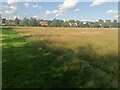
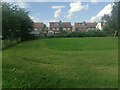
3
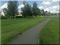
Church Lane Recreation Ground, Kingsbury
Image: © David Howard
Taken: 10 Aug 2021
0.06 miles
4
Church Lane Recreation Ground, Kingsbury
Image: © David Howard
Taken: 10 Aug 2021
0.07 miles
5

Marigolds on Church Lane Recreation Ground, Kingsbury
Image: © David Howard
Taken: 10 Aug 2021
0.07 miles
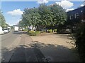
8
Church Lane Recreation Ground, Kingsbury
Image: © David Howard
Taken: 10 Aug 2021
0.09 miles
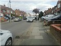
9
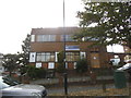
EBC House on Townsend Lane, Kingsbury
This is where I bought my secondhand fridge, I don't know if they still sell white goods.
Image: © David Howard
Taken: 1 Sep 2016
0.10 miles