IMAGES TAKEN NEAR TO
Slough Lane, LONDON, NW9 8QN
Introduction
This page details the photographs taken nearby to Slough Lane, NW9 8QN by members of the Geograph project.
The Geograph project started in 2005 with the aim of publishing, organising and preserving representative images for every square kilometre of Great Britain, Ireland and the Isle of Man.

There are currently over 7.5m images from over14,400 individuals and you can help contribute to the project by visiting https://www.geograph.org.uk
Image Map
Images are licensed for reuse under creativecommons.org/licenses/by-sa/2.0
Notes
- Clicking on the map will re-center to the selected point.
- The higher the marker number, the further away the image location is from the centre of the postcode.
Image Listing (91 Images Found)
Images are licensed for reuse under creativecommons.org/licenses/by-sa/2.0
Image
Details
Distance
1
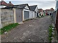
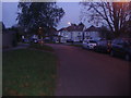
Alleyway off Boycroft Avenue, Kingsbury
Image: © David Howard
Taken: 18 Oct 2022
0.02 miles
2
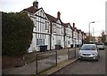
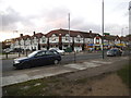
Former shops on Slough Lane, Kingsbury
The Nip In Café and Andy's Barber's from the 60s were replaced by flats in the 90s. The pub on the corner remains as the only unit which has not been converted to residential.
Image: © David Howard
Taken: 5 Nov 2014
0.02 miles
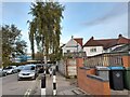
5
Shops on the corner of Church Lane and Slough Lane
Image: © David Howard
Taken: 5 Nov 2014
0.05 miles
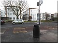
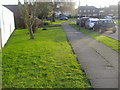
9
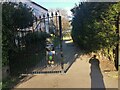
The entrance to Kingsbury Recreation Ground
Image: © David Howard
Taken: 14 Apr 2021
0.06 miles
10
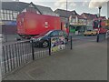
Royal Mail lorry on Church Lane, Kingsbury
Image: © David Howard
Taken: 14 Apr 2021
0.06 miles