IMAGES TAKEN NEAR TO
Sorrel Mead, LONDON, NW9 7FR
Introduction
This page details the photographs taken nearby to Sorrel Mead, NW9 7FR by members of the Geograph project.
The Geograph project started in 2005 with the aim of publishing, organising and preserving representative images for every square kilometre of Great Britain, Ireland and the Isle of Man.

There are currently over 7.5m images from over14,400 individuals and you can help contribute to the project by visiting https://www.geograph.org.uk
Image Map
Images are licensed for reuse under creativecommons.org/licenses/by-sa/2.0
Notes
- Clicking on the map will re-center to the selected point.
- The higher the marker number, the further away the image location is from the centre of the postcode.
Image Listing (224 Images Found)
Images are licensed for reuse under creativecommons.org/licenses/by-sa/2.0
Image
Details
Distance
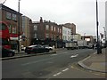
1
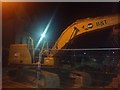
Mechanical digger on Stanley Road, West Hendon
This is part of the ongoing redevelopment of the area since the gradual demolition of the original estate built in the 60s on the bomb site.
Image: © David Howard
Taken: 3 Mar 2020
0.01 miles

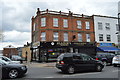
4
St John's Parade, West Hendon Broadway
I caught this fairly ugly terrace just before it'll be demolished as part of the new development of flats.
Image: © David Howard
Taken: 31 Dec 2016
0.02 miles
5
Stanley Road from West Hendon Broadway
All the roads off the Broadway were bombed during the war and the Victorian terraces were cleared and the council estate was built on and behind Perryfield Way, which the council are now planning to redevelop but probably not for a decade or more although they said that twenty years ago as well. In comparison they have had an even bigger scheme they rolled out at the same time for the derelict land around nearby Brent Cross and that never got beyond the plans.
Image: © David Howard
Taken: 30 Oct 2013
0.02 miles
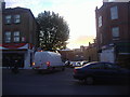
7
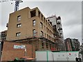
West Hendon redevelopment work on Milton Road
Image: © David Howard
Taken: 15 Jul 2020
0.03 miles
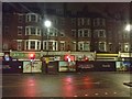
8
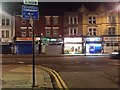
West Hendon Broadway
The roads on the near side were bombed during the war and although the shops survived the roads were blocked and replaced with a housing estate, which is now being demolished and replaced with a far better (but much larger) one.
Image: © David Howard
Taken: 27 Nov 2017
0.03 miles

10
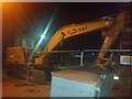
Mechanical digger on Stanley Road, West Hendon
Part of the ongoing redevelopment of the area which was rebuilt in the 60s after being bombed during WWII.
Image: © David Howard
Taken: 3 Mar 2020
0.03 miles