IMAGES TAKEN NEAR TO
Roe Green, LONDON, NW9 0PL
Introduction
This page details the photographs taken nearby to Roe Green, NW9 0PL by members of the Geograph project.
The Geograph project started in 2005 with the aim of publishing, organising and preserving representative images for every square kilometre of Great Britain, Ireland and the Isle of Man.

There are currently over 7.5m images from over14,400 individuals and you can help contribute to the project by visiting https://www.geograph.org.uk
Image Map (Loading...)


Getting Data...Please wait
Leaflet Map data © OpenStreetMap
Images are licensed for reuse under creativecommons.org/licenses/by-sa/2.0
Notes
- Clicking on the map will re-center to the selected point.
- The higher the marker number, the further away the image location is from the centre of the postcode.
Image Listing (63 Images Found)
Images are licensed for reuse under creativecommons.org/licenses/by-sa/2.0
Image
Details
Distance
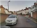
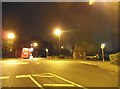
2
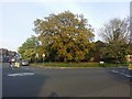
Roundabout between Stag Lane and Roe Green
Image: © David Howard
Taken: 15 Apr 2019
0.03 miles
5
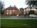
Kingsbury vicarage on Roe Green
It's on the left
Image: © David Howard
Taken: 15 Apr 2019
0.08 miles
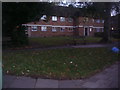
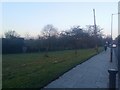
8
Flats in Hay Lane, Colindale
Looking West near the end of Buck Lane
Image: © David Hawgood
Taken: 12 Oct 2005
0.09 miles