IMAGES TAKEN NEAR TO
Kingsbridge Drive, LONDON, NW7 1HN
Introduction
This page details the photographs taken nearby to Kingsbridge Drive, NW7 1HN by members of the Geograph project.
The Geograph project started in 2005 with the aim of publishing, organising and preserving representative images for every square kilometre of Great Britain, Ireland and the Isle of Man.

There are currently over 7.5m images from over14,400 individuals and you can help contribute to the project by visiting https://www.geograph.org.uk
Image Map
Images are licensed for reuse under creativecommons.org/licenses/by-sa/2.0
Notes
- Clicking on the map will re-center to the selected point.
- The higher the marker number, the further away the image location is from the centre of the postcode.
Image Listing (123 Images Found)
Images are licensed for reuse under creativecommons.org/licenses/by-sa/2.0
Image
Details
Distance
1
Flats by Waitrose car park
The health club is on the right
Image: © David Howard
Taken: 7 Jan 2018
0.07 miles
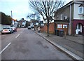
2

Lidbury Square, Mill Hill
Lidbury Square is part of a recent upmarket development just west of Mill Hill East station. This is a view east along the road. The shadow in the foreground is that of one of the pillars that marks the entrance to this "select" development.
Image: © Nigel Mykura
Taken: 27 Sep 2009
0.08 miles
3
Embankment on the former Mill Hill East to Edgware railway line
See Image
Image: © Mike Quinn
Taken: 26 Feb 2020
0.08 miles
4
The course of the former Mill Hill East to Edgware railway line east of Sanders Lane (3)
See Image
Image: © Mike Quinn
Taken: 26 Feb 2020
0.09 miles
5
The course of the former Mill Hill East to Edgware railway line east of Sanders Lane (2)
See Image
Image: © Mike Quinn
Taken: 26 Feb 2020
0.09 miles
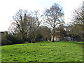
7

The end of the line at Mill Hill East
As part of the ambitious New Works programme of the 1930s, there were extensive plans to expand the northern-most extremities of the Northern line. One of the plans was electrification from Mill Hill East to Edgware and also the expansion of the Northern Line north of Edgware to Bushey Heath. But the onset of the Second World War halted all the expansion projects.
The LNER lines used to branch west just north of Finchley Central, passing through two stations (Mill Hill East and the now closed Mill Hill The Hale) before joining what is known today as the Edgware branch of the Northern Line, just south of Edgware. Only part of this branch was electrified, a single track running to Mill Hill East. The line from Mill Hill East to Edgware continued to be used by goods trains until the mid 1960s when the line was removed.
For more info, see http://underground-history.co.uk/northernh.php and the section "The Northern Heights plan" at http://en.wikipedia.org/wiki/Northern_line.
Image: © Mike Quinn
Taken: 14 Feb 2012
0.10 miles
8
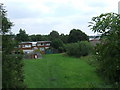
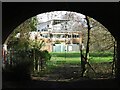
Former railway line, Mill Hill
A railway track used to run across this grassy area. The photograph was taken from a bridge which used to cross the railway. The railway closed in 1964. Housing has since been built across part of the route here.
Image: © Malc McDonald
Taken: 3 Jul 2011
0.10 miles
9
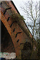
Sanders Lane Bridge
This is one of two bridges that carry Sanders Lane across the dismantled railway between Mill Hill East and the end of the present day footpath at Pages Lane. Brackets remain in place and may be evidence of the proposed electrification of this line. This bridge has been closed to road traffic, the remnants of this end of Sanders Lane being now a footpath. Barnet's corporate plan proposes reopening Sanders Lane to through traffic by 2011 and this bridge will have to be replaced.
Image: © Martin Addison
Taken: 19 Jan 2009
0.10 miles
10
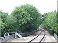
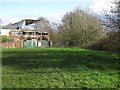
End of the line, Mill Hill East
The end of the railway line at Mill Hill East. The line once continued from here to Edgware, but was closed to passengers in 1939, Freight trains continued to use the line until 1964. Just visible through the trees, housing has since been built across the former railway.
Image: © Malc McDonald
Taken: 3 Jul 2011
0.10 miles