IMAGES TAKEN NEAR TO
Albert Road, LONDON, NW6 5FT
Introduction
This page details the photographs taken nearby to Albert Road, NW6 5FT by members of the Geograph project.
The Geograph project started in 2005 with the aim of publishing, organising and preserving representative images for every square kilometre of Great Britain, Ireland and the Isle of Man.

There are currently over 7.5m images from over14,400 individuals and you can help contribute to the project by visiting https://www.geograph.org.uk
Image Map
Images are licensed for reuse under creativecommons.org/licenses/by-sa/2.0
Notes
- Clicking on the map will re-center to the selected point.
- The higher the marker number, the further away the image location is from the centre of the postcode.
Image Listing (133 Images Found)
Images are licensed for reuse under creativecommons.org/licenses/by-sa/2.0
Image
Details
Distance
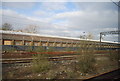
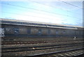
2
Railway Lines from Salusbury Road
The tracks nearest the camera are used by local trains. The tracks in the distance on the left, with the overhead power lines are the West Coast Main Line
Image: © Oxyman
Taken: 4 Jun 2007
0.04 miles
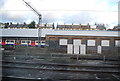
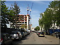
7
Albert Road, Paddington
Just been built the new buildings on the right
Image: © Alexander P Kapp
Taken: 16 Jul 2012
0.07 miles
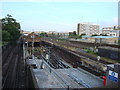
10
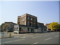
The Falcon public house, Queens Park
Image: © Stacey Harris
Taken: 30 Apr 2011
0.08 miles