IMAGES TAKEN NEAR TO
Lismore Circus, LONDON, NW5 4SF
Introduction
This page details the photographs taken nearby to Lismore Circus, NW5 4SF by members of the Geograph project.
The Geograph project started in 2005 with the aim of publishing, organising and preserving representative images for every square kilometre of Great Britain, Ireland and the Isle of Man.

There are currently over 7.5m images from over14,400 individuals and you can help contribute to the project by visiting https://www.geograph.org.uk
Image Map
Images are licensed for reuse under creativecommons.org/licenses/by-sa/2.0
Notes
- Clicking on the map will re-center to the selected point.
- The higher the marker number, the further away the image location is from the centre of the postcode.
Image Listing (278 Images Found)
Images are licensed for reuse under creativecommons.org/licenses/by-sa/2.0
Image
Details
Distance
1
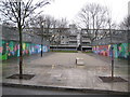
Gospel Oak: Former Gospel Oak Grove
This is about the only surviving remnant of a Victorian residential road called Gospel Oak Grove that ran around the west and south side of Lismore Circus, before much of the area was redeveloped in the 1960s following Second World War bomb damage. This section probably only survived because it is actually the bridge over the former Midland Railway below. The Ludham housing block is directly ahead, built over the top of the junction of Gospel Oak Grove with Lismore Road.
Image: © Nigel Cox
Taken: 14 Feb 2010
0.02 miles
2
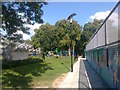
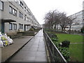
Footpath beside the railway to Lismore Circus
This path leads from Southampton Road towards Grafton Road.
It passes Lismore Circus (in the background), a roundabout for paths surrounded by trees.
A small playpark is on the left.
Image: © David Anstiss
Taken: 15 Aug 2017
0.02 miles
3
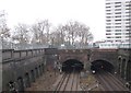
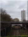
Gospel Oak: Site of the former Haverstock Hill railway station
When the Midland Railway extended their line southwards into St Pancras in 1868 they built several suburban stations close in to the centre of London. However, having so many stations slowed down commuter train speeds, and with the additional competition from other forms of transport, such as buses and the Underground railway, three of them (this one, Camden Road and Finchley Road) were closed. This one at Haverstock Hill shut in 1916 as was the Camden Road one. Finchley Road survived until 1927, leaving only the Kentish Town and West Hampstead stations surviving in the immediate area.
Haverstock Hill station was built to serve the Victorian housing estate radiating out from Lismore Circus, the site of which is shown by the group of trees in the distance to the left. The station only served the slow lines on the left so the platforms would have been where the grassy areas are now.
By one of those odd quirks of geography this view is looking slightly north of east although it shows the railway heading generally southwards towards St Pancras. The photo was taken from Image
Image: © Nigel Cox
Taken: 14 Feb 2010
0.03 miles
4
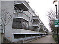
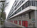
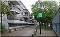
Gospel Oak: Lismore Circus Estate: Ludham (2)
Ludham, and its parallel housing block, Waxham, are named after two Norfolk villages Image and Image respectively. The blocks are about 240 metres long. This is the south side of Ludham. There are copious images of the estate, when it was brand new, on the English Heritage Viewfinder website. This link goes to an image taken, I think, from virtually the same location http://viewfinder.english-heritage.org.uk/search/reference.aspx?uid=145906&index=12&mainQuery=lismore&searchType=all&form=home
Image: © Nigel Cox
Taken: 14 Feb 2010
0.03 miles
5
Gospel Oak: Lismore Circus Estate: Waxham
Waxham, and its parallel housing block, Ludham, are named after two Norfolk villages Image and Image respectively. The blocks are continuous and about 240 metres long. This is the Mansfield Road side of Waxham. There are copious images of the estate, when it was brand new, on the English Heritage Viewfinder website here http://viewfinder.english-heritage.org.uk/default.aspx
Image: © Nigel Cox
Taken: 14 Feb 2010
0.03 miles
6
Gospel Oak: Lismore Circus Estate: Ludham (1)
Ludham, on the left, and Waxham on the right, are two parallel blocks of continuous housing units dating from the early 1970s. They are both about 240 metres long. There are copious photographs of this estate when it was brand new on the English Heritage Viewfinder website here http://viewfinder.english-heritage.org.uk/default.aspx
Image: © Nigel Cox
Taken: 14 Feb 2010
0.04 miles
7
Railway Tracks and Tower Block, Southampton Road NW5
Taken from the road bridge
Image: © Robin Sones
Taken: 4 Jan 2012
0.04 miles
8
Footbridge to Wendling Estate
This very wide bridge leads from the Ludham and Waxham Blocks (with 532 flats) near Mansfield Road, towards an estate on Havestock Road.
It passes over the national railway line to Upper Holloway station and the London Underground network (on the Northern line) leading towards Kentish Town.
Image: © David Anstiss
Taken: 15 Aug 2017
0.05 miles
9
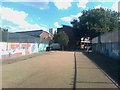
Housing estate off Southampton Road, Gospel Oak
The railway runs along the wall.
Image: © David Howard
Taken: 28 Apr 2020
0.05 miles
10
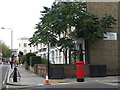
Mansfield Road / Roderick Road, NW3
Shows the location of Image
Image: © Mike Quinn
Taken: 30 Oct 2008
0.06 miles