IMAGES TAKEN NEAR TO
Croftdown Road, LONDON, NW5 1HA
Introduction
This page details the photographs taken nearby to Croftdown Road, NW5 1HA by members of the Geograph project.
The Geograph project started in 2005 with the aim of publishing, organising and preserving representative images for every square kilometre of Great Britain, Ireland and the Isle of Man.

There are currently over 7.5m images from over14,400 individuals and you can help contribute to the project by visiting https://www.geograph.org.uk
Image Map
Images are licensed for reuse under creativecommons.org/licenses/by-sa/2.0
Notes
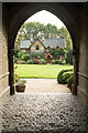
- Clicking on the map will re-center to the selected point.
- The higher the marker number, the further away the image location is from the centre of the postcode.
Image Listing (165 Images Found)
Images are licensed for reuse under creativecommons.org/licenses/by-sa/2.0
Image
Details
Distance
1
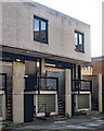
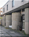
Housing terrace, Winscombe Street
The image hows part of a housing terrace built in the 1960s to a design by architect Neave Brown. It is Grade II listed : description at this https://historicengland.org.uk/listing/the-list/list-entry/1410085. Neave Brown was an important figure in the development of social housing projects in the London Borough of Camden. His contribution belatedly received recognition with the award of the Royal Institute of British Architects Royal Gold Medal 2017.
Image: © Jim Osley
Taken: 12 Oct 2017
0.07 miles
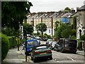
3
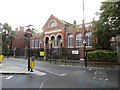
Highgate Branch Library
Wonderful-looking building along Chester Road, though I'm unsure if it is still a library.
Image: © Bill Nicholls
Taken: 14 Sep 2015
0.07 miles
4
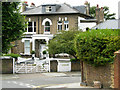
Bramshill Gardens, Dartmouth Park
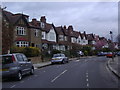
Seen at the junction with Dartmouth Park Avenue. Perhaps because it has no station named after it, or because it is tucked away between Kentish Town and Highgate, Dartmouth Park is a relatively little known Victorian suburb; it is nevertheless an intriguing place. The Earl of Dartmouth acquired the land in the middle of the 18th century, but the area was not developed for another century. The streets tend to be a little narrower and have a more intimate quality than similar contemporary suburbs.
Image: © Stephen McKay
Taken: 22 Jul 2008
0.08 miles
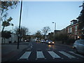
6
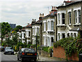
Laurier Road, Dartmouth Park
Fine Victorian villas line this street towards the southern end of Dartmouth Park.
Image: © Stephen McKay
Taken: 22 Jul 2008
0.10 miles
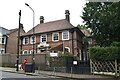
9
House, Holly Village, Highgate
One of a group houses comprising Holly Village built in 1865 to the designs of architect Henry Darbishire. Grade II* listed : description at this https://historicengland.org.uk/listing/the-list/list-entry/1379116.
Image: © Jim Osley
Taken: 1 Nov 2017
0.13 miles
10
Dartmouth Park Road, Dartmouth Park
Dartmouth Park Road falls away fairly steeply from its junction with Dartmouth Park Hill, away from the high ground on which Highgate is built. The Royal Free Hospital is visible in the distance.
Image: © Stephen McKay
Taken: 22 Jul 2008
0.14 miles