IMAGES TAKEN NEAR TO
Southfields, LONDON, NW4 4NA
Introduction
This page details the photographs taken nearby to Southfields, NW4 4NA by members of the Geograph project.
The Geograph project started in 2005 with the aim of publishing, organising and preserving representative images for every square kilometre of Great Britain, Ireland and the Isle of Man.

There are currently over 7.5m images from over14,400 individuals and you can help contribute to the project by visiting https://www.geograph.org.uk
Image Map (Loading...)


Getting Data...Please wait
Leaflet Map data © OpenStreetMap
Images are licensed for reuse under creativecommons.org/licenses/by-sa/2.0
Notes
- Clicking on the map will re-center to the selected point.
- The higher the marker number, the further away the image location is from the centre of the postcode.
Image Listing (56 Images Found)
Images are licensed for reuse under creativecommons.org/licenses/by-sa/2.0
Image
Details
Distance
1
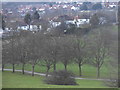
Sunnyhill Park, Hendon
The steep slope from the east means on a clear day you can see around 180 degrees at least from Edgware to Wembley.
Image: © David Howard
Taken: 21 Jan 2014
0.02 miles
2
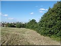
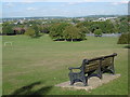
Sunny Hill Park
Sunny Hill Park was created in the 1920s when Hendon Council purchased Sunnyhill Fields in 1921, which belonged to Church Farmhouse, whose garden adjoins the south end of the park. It also includes an area that was once part of the churchyard of Hendon parish church of St Mary. The park opened in 1922. It was enlarged in 1929 when further land was added. Church Farm House was a museum but has now sadly closed - see http://www.geograph.org.uk/photo/4701781
The park became a popular viewing point during the 1920s and 1930s for watching air displays at Hendon Aerodrome and still provides fine views to the north and to the west.
Image: © Marathon
Taken: 5 Oct 2016
0.08 miles
4
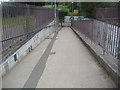
Subway on Watford Way, Hendon
The entrance to Sunnyhill Park is behind it.
Image: © David Howard
Taken: 23 Jul 2013
0.09 miles
5
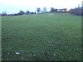
Sunnyhill Park, Hendon
It must have been a real task finding an area flat enough for a football pitch, more so for two.
Image: © David Howard
Taken: 21 Jan 2014
0.09 miles
6
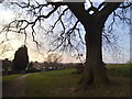
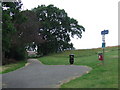
Sunny Hill Park, Hendon
Sunny Hill Park in Hendon, North West London.
Image: © Malc McDonald
Taken: 3 Jul 2011
0.10 miles
7
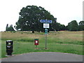
Sunny Hill Park, Hendon
A path in Sunny Hill Park, in Hendon, North West London. The signs indicate that the path is a cycle route.
Image: © Malc McDonald
Taken: 3 Jul 2011
0.10 miles
8
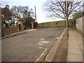
The entrance to Sunnyhill Park on Sunny Hill
Image: © David Howard
Taken: 25 Mar 2014
0.10 miles
9
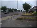
Watford Way, Hendon
This is part of the A41 which goes into Central London via Hampstead and The Midlands and beyond in the other direction.
Image: © David Howard
Taken: 23 Jul 2013
0.11 miles
10
Sunny Hill Park
Sunny Hill Park was created in the 1920s when Hendon Council purchased Sunnyhill Fields in 1921, which belonged to Church Farmhouse, whose garden adjoins the south end of the park. It also includes an area that was once part of the churchyard of Hendon parish church of St Mary. The park opened in 1922. It was enlarged in 1929 when further land was added. Church Farm House was a museum but has now sadly closed - see http://www.geograph.org.uk/photo/4701781
The park became a popular viewing point during the 1920s and 1930s for watching air displays at Hendon Aerodrome and still provides fine views to the north and to the west.
Image: © Marathon
Taken: 5 Oct 2016
0.11 miles