IMAGES TAKEN NEAR TO
Corrigan Close, LONDON, NW4 1TF
Introduction
This page details the photographs taken nearby to Corrigan Close, NW4 1TF by members of the Geograph project.
The Geograph project started in 2005 with the aim of publishing, organising and preserving representative images for every square kilometre of Great Britain, Ireland and the Isle of Man.

There are currently over 7.5m images from over14,400 individuals and you can help contribute to the project by visiting https://www.geograph.org.uk
Image Map (Loading...)


Getting Data...Please wait
Leaflet Map data © OpenStreetMap
Images are licensed for reuse under creativecommons.org/licenses/by-sa/2.0
Notes
- Clicking on the map will re-center to the selected point.
- The higher the marker number, the further away the image location is from the centre of the postcode.
Image Listing (70 Images Found)
Images are licensed for reuse under creativecommons.org/licenses/by-sa/2.0
Image
Details
Distance
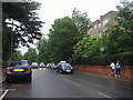
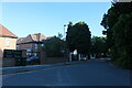
4
Parson Street, Hendon
Looking north east on the B552.
Image: © JThomas
Taken: 15 Apr 2017
0.08 miles
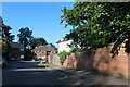
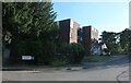
6
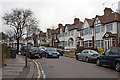
Ashley Lane, Hendon
The old Hendon Hall Hotel is on the right, which has been partially demolished to a care home.
Image: © David Howard
Taken: 28 Jul 2021
0.12 miles
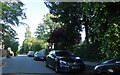
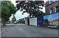
9
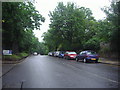
Parson Street, Hendon
What looks like a country road is actually in the middle of a London suburb
Image: © David Howard
Taken: 3 Jun 2008
0.14 miles
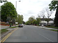
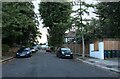
10
Glebe Crescent
Semi-detached housing on this road which runs between Finchley Lane and Parson Street. Viewed from the Finchley Lane end.
Image: © Martin Addison
Taken: 14 Dec 2008
0.15 miles