IMAGES TAKEN NEAR TO
Cenacle Close, LONDON, NW3 7UE
Introduction
This page details the photographs taken nearby to Cenacle Close, NW3 7UE by members of the Geograph project.
The Geograph project started in 2005 with the aim of publishing, organising and preserving representative images for every square kilometre of Great Britain, Ireland and the Isle of Man.

There are currently over 7.5m images from over14,400 individuals and you can help contribute to the project by visiting https://www.geograph.org.uk
Image Map
Images are licensed for reuse under creativecommons.org/licenses/by-sa/2.0
Notes
- Clicking on the map will re-center to the selected point.
- The higher the marker number, the further away the image location is from the centre of the postcode.
Image Listing (68 Images Found)
Images are licensed for reuse under creativecommons.org/licenses/by-sa/2.0
Image
Details
Distance
1
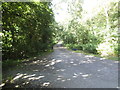
Track from West Heath Road to North End Road
Leading to Golders Hill Park and going through West Heath
Image: © David Howard
Taken: 10 Jun 2014
0.05 miles
4
Way in to Hampstead Heath (West Heath)
From West Heath Road.
Image: © Robin Webster
Taken: 19 Mar 2011
0.06 miles
5
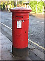
Victorian postbox, West Heath Road / Cenacle Close, NW3
Image: © Mike Quinn
Taken: 17 Dec 2008
0.06 miles

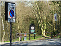
7
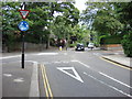
Mini Roundabout
Four unnumbered roads meet at this mini roundabout.
Image: © Oxyman
Taken: 8 Jun 2007
0.07 miles
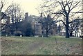
8
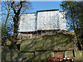
Building work above Platt's Lane, NW3
Image: © Robin Webster
Taken: 19 Mar 2011
0.07 miles
9
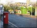
West Heath Road, NW3 (2)
Shows the location of Image
Image: © Mike Quinn
Taken: 17 Dec 2008
0.07 miles
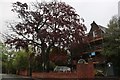
10
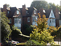
Platt's Lane, Child's Hill
These large houses seen to tower over Platt's Lane as it descends from the edges of Hampstead Heath.
Image: © Stephen McKay
Taken: 13 Sep 2019
0.07 miles