IMAGES TAKEN NEAR TO
Garnett Road, LONDON, NW3 2XN
Introduction
This page details the photographs taken nearby to Garnett Road, NW3 2XN by members of the Geograph project.
The Geograph project started in 2005 with the aim of publishing, organising and preserving representative images for every square kilometre of Great Britain, Ireland and the Isle of Man.

There are currently over 7.5m images from over14,400 individuals and you can help contribute to the project by visiting https://www.geograph.org.uk
Image Map
Images are licensed for reuse under creativecommons.org/licenses/by-sa/2.0
Notes
- Clicking on the map will re-center to the selected point.
- The higher the marker number, the further away the image location is from the centre of the postcode.
Image Listing (273 Images Found)
Images are licensed for reuse under creativecommons.org/licenses/by-sa/2.0
Image
Details
Distance
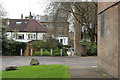
1
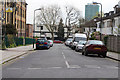
Garnett Road, Belsize Park
In response to the demand for lower middle- and working-class housing in 1905-6 Hampstead borough council bought a site at the north side of Garnett Road and built Park Buildings, three blocks of flats, on the left of the photograph. In 1932 Glenloch Investment Co. began building on a site acquired from the Haverstock Lodge estate where it put up 51 small Art Deco styled houses in Lawn, Garnett and Upper Park roads between 1932 and 1934, on the right. Note the curved windows in the bays.
Image: © Kate Jewell
Taken: 31 Mar 2014
0.01 miles
2
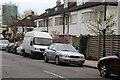
Art Deco style housing on Garnett Road, Belsize Park, NW3
Although most of the Belsize estates were still classified in 1930 as middle-class and wealthy, there had been some social decline. There was more demand for lower middle- and working-class houses in areas which had previously seemed unattractive, like the northern part of the Haverstock Lodge estate. The Glenloch Investment Co. began building on sites in Lawn, Lower Cross (later Garnett Road), and Upper Park roads between 1932 and 1934. It is refreshing to see that the majority of these Art Deco styled houses have retained the curved glass in the front bays. They are considered an important feature of the Parkhill and Upper Park Conservation Area.
Image: © Kate Jewell
Taken: 31 Mar 2014
0.01 miles

5
Art Deco style housing on Upper Park Road, Belsize Park
Although most of the Belsize estates were still classified in 1930 as middle-class and wealthy, there had been some social decline. There was more demand for lower middle- and working-class houses in areas which had previously seemed unattractive, like the northern part of the Haverstock Lodge estate. The Glenloch Investment Co. began building on sites in Lawn, Lower Cross (later Garnett Road), and Upper Park roads between 1932 and 1934. It is refreshing to see that the majority of these Art Deco styled houses have retained the curved glass in the front bays. They are considered an important feature of the Parkhill and Upper Park Conservation Area.
Image: © Kate Jewell
Taken: 31 Mar 2014
0.03 miles
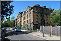
6
Looking towards Parkhill Road, Belsize Park
Looking through the parking area for Barn Field, see Image, to the right towards Parkhill Road. The matching block of flats, Wood Field, is immediately behind with the back of the 1930's houses on Parkhill Road to the left.
Image: © Kate Jewell
Taken: 31 Mar 2014
0.03 miles
7
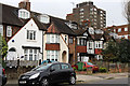
At the north end of Upper Park Road, Belsize Park
Although most of the Belsize estates were still classified in 1930 as middle-class and wealthy, there had been some social decline. There was more demand for lower middle- and working-class houses in areas which had previously seemed unattractive, like the northern part of the Haverstock Lodge estate. Mixed Arts and Crafts styles are evident in this row of terraced housing built in the latter part of this period.
Image: © Kate Jewell
Taken: 31 Mar 2014
0.04 miles
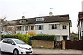
8
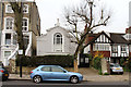
Housing on Upper Park Road, Belsize Park
No.51, Upper Park Road is completely out of character compared to the older Victorian housing and the early 20th Century developments. It looks like it was a chapel, a reading room or something similar but I haven't been able to find out any detail.
Image: © Kate Jewell
Taken: 31 Mar 2014
0.05 miles

10
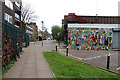
Apartment blocks on Upper Park Road, Belsize Park, NW3
The Fleet Community Centre is on the right. On the left from front to back are Palgrave House (1963), four terraced houses (1960s?) and a block of and Park Dwellings on the corner of Garnett Road (1905). Beyond these is Barn Field (1945) and right in the distance the Victorian villas on the southern part of Upper Park Road can be seen.
Image: © Kate Jewell
Taken: 31 Mar 2014
0.06 miles