IMAGES TAKEN NEAR TO
New End, LONDON, NW3 1HT
Introduction
This page details the photographs taken nearby to New End, NW3 1HT by members of the Geograph project.
The Geograph project started in 2005 with the aim of publishing, organising and preserving representative images for every square kilometre of Great Britain, Ireland and the Isle of Man.

There are currently over 7.5m images from over14,400 individuals and you can help contribute to the project by visiting https://www.geograph.org.uk
Image Map
Images are licensed for reuse under creativecommons.org/licenses/by-sa/2.0
Notes
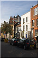
- Clicking on the map will re-center to the selected point.
- The higher the marker number, the further away the image location is from the centre of the postcode.
Image Listing (679 Images Found)
Images are licensed for reuse under creativecommons.org/licenses/by-sa/2.0
Image
Details
Distance
1
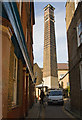
New End Chimney
This chimney, which has grade II listed status, was built in 1898 for the boilerhouse of the New End workhouse infirmary - later to become New End Hospital. The hospital was given over to residential use in 1996-8 and the chimney was retained as a local landmark. Information from Camden Council website - fuller details at http://mycamden.camden.gov.uk/gdw/T/ListedBuildingDetail?LbNo=1193&xsl=ListedBuildingDetail.xsl
Image: © Martin Addison
Taken: 10 Oct 2008
0.01 miles
2
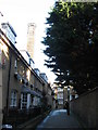
Mansfield Place, NW3 (3)
Leading towards the Image (photo by ceridwen).
Image: © Mike Quinn
Taken: 17 Dec 2008
0.01 miles
3
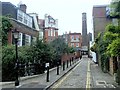
New End, Hampstead
View along the narrow back street. The chimney is associated with the former workhouse.
Image: © Andrew Hill
Taken: 1 Oct 2013
0.02 miles
4
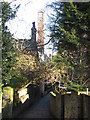
Mansfield Place, NW3
See also Image (photo by ceridwen).
Image: © Mike Quinn
Taken: 17 Dec 2008
0.02 miles
6
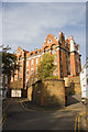
New End Primary School
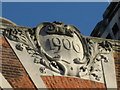
Seen from Murray Terrace - the cobbled street on the left. On the right is Boad's Mews. The school building dates from 1906.
Image: © Martin Addison
Taken: 10 Oct 2008
0.02 miles
7
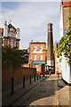
Streatley Place
Looking along this narrow cobbled street towards the junction with New End. A pedestrian crosses into New End from Boad's Mews. The chimney beyond is the surviving remnant of New End Hospital. The large building on the Left is New End Primary School. The building on the corner of Streatley Place and Boad's Mews was once a public house, now in use a private dwelling.
Image: © Martin Addison
Taken: 10 Oct 2008
0.02 miles
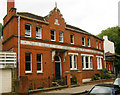
8
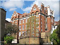
New End Primary School
Grade II listed http://list.english-heritage.org.uk/resultsingle.aspx?uid=1322110 , built circa 1906.
Image: © Oast House Archive
Taken: 15 Apr 2012
0.03 miles
9
New End
A mixture of housing styles in this terrace on New End. The large building looming beyond is New End Primary School.
Image: © Martin Addison
Taken: 10 Oct 2008
0.03 miles
10
Former public baths and washhouse, Hampstead, London NW3
Situated in Flask Walk, Hampstead, the first baths and washhouses for the public were built by the Wells and Campden charity in 1888. They remained in use until 1978, when the building was converted into residential use.
Image: © Jim Osley
Taken: 19 Jun 2010
0.03 miles