IMAGES TAKEN NEAR TO
Mascotts Close, LONDON, NW2 6NS
Introduction
This page details the photographs taken nearby to Mascotts Close, NW2 6NS by members of the Geograph project.
The Geograph project started in 2005 with the aim of publishing, organising and preserving representative images for every square kilometre of Great Britain, Ireland and the Isle of Man.

There are currently over 7.5m images from over14,400 individuals and you can help contribute to the project by visiting https://www.geograph.org.uk
Image Map
Images are licensed for reuse under creativecommons.org/licenses/by-sa/2.0
Notes
- Clicking on the map will re-center to the selected point.
- The higher the marker number, the further away the image location is from the centre of the postcode.
Image Listing (61 Images Found)
Images are licensed for reuse under creativecommons.org/licenses/by-sa/2.0
Image
Details
Distance
3
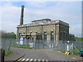
Cricklewood Water Pumping Station off St Michael's Road, London NW2
Image: © Robin Sones
Taken: 24 Apr 2007
0.12 miles
4
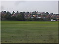
Playing field on Gladstone Park
Looking towards the houses on Dollis Hill
Image: © David Howard
Taken: 28 Aug 2013
0.13 miles
5
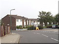
Coppermead Close, Dollis Hill
These post-war houses are between Cricklewood and the top of Dollis Hill. Photo taken from the junction with Mount Road.
Image: © David Hawgood
Taken: 5 Oct 2005
0.13 miles
6
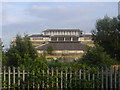
Thames Water building by Gladstone Park
There is a goods railway line behind the railings and before the building.
Image: © David Howard
Taken: 28 Aug 2013
0.13 miles
7

Cricklewood Pumping Station
Located between St. Michael's Road and the Dudding Hill Loop railway line connecting Cricklewood with Acton, opposite St.Michael's Church.
The station forms part of the Metropolitan Water Board's north London network of supply and is on the 42" and 48" mains that connect with the Lea Valley and the Waterworks at Kempton Park. See Image for part of the route through Southall and Image for part of the route through Golders Green.
Image: © Martin Addison
Taken: 23 Oct 2009
0.13 miles
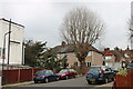
9
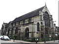
St. Michael's Church of Jesus Christ (Apostolic), St. Michael's Road / Mora Road, NW2
Image: © Mike Quinn
Taken: 2 Aug 2011
0.15 miles