IMAGES TAKEN NEAR TO
Mark Twain Drive, LONDON, NW2 6FU
Introduction
This page details the photographs taken nearby to Mark Twain Drive, NW2 6FU by members of the Geograph project.
The Geograph project started in 2005 with the aim of publishing, organising and preserving representative images for every square kilometre of Great Britain, Ireland and the Isle of Man.

There are currently over 7.5m images from over14,400 individuals and you can help contribute to the project by visiting https://www.geograph.org.uk
Image Map
Images are licensed for reuse under creativecommons.org/licenses/by-sa/2.0
Notes
- Clicking on the map will re-center to the selected point.
- The higher the marker number, the further away the image location is from the centre of the postcode.
Image Listing (105 Images Found)
Images are licensed for reuse under creativecommons.org/licenses/by-sa/2.0
Image
Details
Distance
2
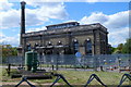
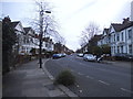
Cricklewood Pumping Station
Viewed from a fence at the edge of St Michaels Road.
Cricklewood Pumping Station was built in 1905 to supply water to London's north west suburbs at a time when most of the local residents obtained their water from rainwater cisterns or ponds. Although not in use since the station converted from steam power to electricity in the late 1950s, the 135 feet (41m) tall chimney remains a distinctive local landmark.
http://www.geograph.org.uk/photo/2971844 to a closer view of the valve wheel and cylinder.
Image: © Jaggery
Taken: 12 May 2012
0.03 miles
3
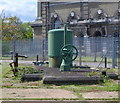
Closeup of a cylinder and valve wheel, Cricklewood Pumping Station
Viewed from the St Michaels Road side of the pumping station. http://www.geograph.org.uk/photo/2971838
Image: © Jaggery
Taken: 12 May 2012
0.03 miles
5
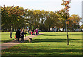
Gladstone Park
Pedestrians enjoy the glorious autumn sunshine with a stroll through the park. There's just enough of a nip in the air to encourage the wearing of coats for those who don't intend to jog.
Image: © Martin Addison
Taken: 23 Oct 2009
0.04 miles
7
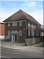
Cricklewood Library and Brent Archive, Oman Avenue, London NW2
Image: © Robin Sones
Taken: 24 Apr 2007
0.05 miles
8
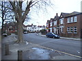
Corner of Olive Road and St Michaels Road, London NW2
St Michaels Road is on the left, Olive Road on the right.
To the left of the modern name sign for St Michaels Road is an older sign embossed on the wall. It shows ST MICHAELS ROAD N.W. which dates it to the time before numbers were added to postal districts.
In 1846, Sir Rowland Hill's system of dividing the capital into 10 separate postal districts, based on compass points, was introduced for all addresses within a circle of 12 miles radius from central London. A refinement introduced during World War I was the introduction of sub-districts which were given a serial number, such as NW2.
Image: © Jaggery
Taken: 12 May 2012
0.05 miles
9
Olive Road, London NW2
A view ESE from opposite St Michaels Road.
Image: © Jaggery
Taken: 12 May 2012
0.05 miles
10
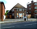
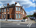
Former Cricklewood Library and Brent Archive
Located on the east side of Olive Road, facing Gladstone Park. This is one of six Brent council libraries that were shut down in October 2011. Here's a view http://www.geograph.org.uk/photo/412709 from 2007.
Despite many protests, this branch and those in Braham Park, Tokyngton, Kensal Rise, Preston and Neasden were shut down after a High Court judge ruled in favour of the council. Campaigners had sought a judicial review to prevent the closures which are projected to save the council £1 million.
A large placard on the building in this May 2012 view shows WE ARE STILL FIGHTING. Another placard shows Save Cricklewood Library. Various notices attached to a large board show messages such as
"We are still working on a community solution" and "This building has been valued at £¾ million. Brent Council want to GIVE it back to All Souls College" This last message is a reference to the fact that Cricklewood and Kensal Rise library buildings are owned by All Souls College Oxford. Both have covenants that they must be used only as a library.
Image: © Jaggery
Taken: 12 May 2012
0.06 miles