IMAGES TAKEN NEAR TO
Chichele Road, LONDON, NW2 3DH
Introduction
This page details the photographs taken nearby to Chichele Road, NW2 3DH by members of the Geograph project.
The Geograph project started in 2005 with the aim of publishing, organising and preserving representative images for every square kilometre of Great Britain, Ireland and the Isle of Man.

There are currently over 7.5m images from over14,400 individuals and you can help contribute to the project by visiting https://www.geograph.org.uk
Image Map
Images are licensed for reuse under creativecommons.org/licenses/by-sa/2.0
Notes
- Clicking on the map will re-center to the selected point.
- The higher the marker number, the further away the image location is from the centre of the postcode.
Image Listing (141 Images Found)
Images are licensed for reuse under creativecommons.org/licenses/by-sa/2.0
Image
Details
Distance
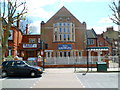
1
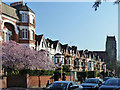
Houses on Chichele Road, NW2
Probably built in Edwardian times.
Image: © Robin Webster
Taken: 19 Mar 2011
0.03 miles
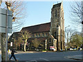
3
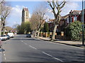
St Gabriels Church
St Gabriels Church on Walm Lane Cricklewood
Image: © Shaun Ferguson
Taken: 1 Apr 2009
0.03 miles
5
Dar al-Islam Foundation, Cricklewood, London NW2
Located at 61 Anson Road, on the corner of Chichele Road.
Dar al-Islam is Arabic for house or abode of Islam.
Image: © Jaggery
Taken: 12 May 2012
0.05 miles
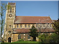
6
St Gabriel's, Cricklewood
On the corner of Walm Lane and Walm Lane!
Image: © Robin Webster
Taken: 19 Mar 2011
0.05 miles
7
Cricklewood: St Gabriel's Church
When the church was built in 1897, to the design of Mr P Philip Day, it was on its own, surrounded by fields, and about mid-way along Walm Lane, between Cricklewood to the north and Willesden Green to the south. It was consecrated on 7 October 1897, but less than three years later, on 27 July 1900, fire broke out in the roof and the church was gutted. It was rebuilt and eventually reopened in 1906. However further tragedy was to befall the church in 1912 when its original vicar, George Marsh Clibborn, was killed in a railway accident in Sweden.
However today's church presents a much happier picture as can be seen from its vibrant website here http://www.st-gabriels.org/Groups/29310/St_Gabriels_Cricklewood.aspx
The south and west boundaries of the church are lined with trees making finding a photographic viewpoint quite difficult.
Image: © Nigel Cox
Taken: 18 Apr 2010
0.05 miles
8
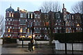
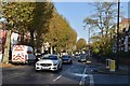
Chichele Mansions, Cricklewood
NW2 and NW10 have many suburbs within them, and there is now no exact known boundary where Cricklewood and Willesden Green begin (as both are in NW2), but the Walm Lane/Chichele Road boundary appears to indicate the original official line. My mother was born and lived around the corner from 1933-47.
Image: © David Howard
Taken: 5 Jan 2021
0.05 miles
9
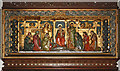
St Gabriel, Walm Lane, Cricklewood - Reredos
Image: © John Salmon
Taken: 1 Jul 2011
0.06 miles
10
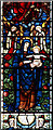
St Gabriel, Walm Lane, Cricklewood - Stained glass window
Image: © John Salmon
Taken: 1 Jul 2011
0.06 miles