IMAGES TAKEN NEAR TO
Sanderstead Avenue, LONDON, NW2 1SG
Introduction
This page details the photographs taken nearby to Sanderstead Avenue, NW2 1SG by members of the Geograph project.
The Geograph project started in 2005 with the aim of publishing, organising and preserving representative images for every square kilometre of Great Britain, Ireland and the Isle of Man.

There are currently over 7.5m images from over14,400 individuals and you can help contribute to the project by visiting https://www.geograph.org.uk
Image Map
Images are licensed for reuse under creativecommons.org/licenses/by-sa/2.0
Notes
- Clicking on the map will re-center to the selected point.
- The higher the marker number, the further away the image location is from the centre of the postcode.
Image Listing (41 Images Found)
Images are licensed for reuse under creativecommons.org/licenses/by-sa/2.0
Image
Details
Distance
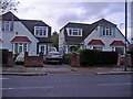
4
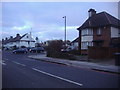
The Vale, Cricklewood
At junction of Hendon Way
Image: © David Howard
Taken: 20 Jan 2011
0.20 miles
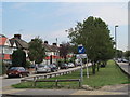
5
SW end of The Vale, London NW11
Residential dual carriageway viewed from Claremont Road.
Image: © Jaggery
Taken: 13 May 2012
0.20 miles
6
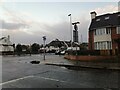
The Vale at the junction of Hendon Way
Image: © David Howard
Taken: 28 Oct 2020
0.21 miles
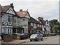
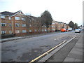
8
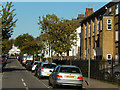
Caddington Road, Cricklewood
Looking along Caddington Road from the junction with Gillingham Road.
Image: © Stephen McKay
Taken: 13 Sep 2019
0.21 miles
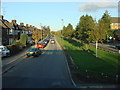
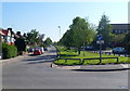
9
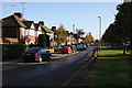
The Vale
Seen from the junction with Claremont Road. This suburban street is divided by a central green.
Image: © Martin Addison
Taken: 23 Oct 2009
0.21 miles