IMAGES TAKEN NEAR TO
Prayle Grove, LONDON, NW2 1BE
Introduction
This page details the photographs taken nearby to Prayle Grove, NW2 1BE by members of the Geograph project.
The Geograph project started in 2005 with the aim of publishing, organising and preserving representative images for every square kilometre of Great Britain, Ireland and the Isle of Man.

There are currently over 7.5m images from over14,400 individuals and you can help contribute to the project by visiting https://www.geograph.org.uk
Image Map
Images are licensed for reuse under creativecommons.org/licenses/by-sa/2.0
Notes
- Clicking on the map will re-center to the selected point.
- The higher the marker number, the further away the image location is from the centre of the postcode.
Image Listing (56 Images Found)
Images are licensed for reuse under creativecommons.org/licenses/by-sa/2.0
Image
Details
Distance
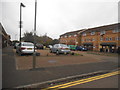
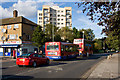
2
The entrance to Clitterhouse Playing Fields
Image: © David Howard
Taken: 29 Oct 2015
0.07 miles
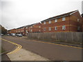
3
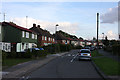
Prayle Grove
An interesting style of semi-detached housing along this street with traditional brick built houses intermixed with prefab designs. The prefab houses were built to a Canadian design and initially had functioning fireplaces and oil radiators. Between 1979-1983 these were replaced by gas central heating. Information regarding the prefabs from Tim Woods.
Image: © Martin Addison
Taken: 10 Oct 2009
0.10 miles
5
Clitterhouse Playing Fields, Cricklewood
Image: © David Howard
Taken: 30 Apr 2020
0.11 miles
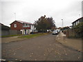
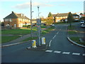
6
Strawberry Jam
A little bit of traffic congestion on Claremont Road. This is the effect of putting a traffic island at the same location as a bus stop. Behind the trees is one of the tower blocks on the Whitefield Estate. The road on the left is Claremont Way.
Image: © Martin Addison
Taken: 10 Oct 2009
0.13 miles
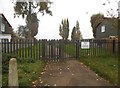
7
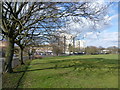
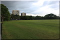
Clitterhouse Recreation Ground
Until 1926 Clitterhouse Recreation Ground formed part of Clitterhouse Farm (or 'Clutterhouse' on some old maps). It is now a large, rather featureless open space, mainly devoted to sports pitches. There are good views up to Hampstead Heath and Hampstead Garden Suburb.
In this photograph, Claremont Road is to the left and the tower blocks are in Whitefield Avenue.
Image: © Marathon
Taken: 4 Mar 2015
0.13 miles
8
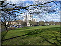
Clitterhouse Recreation Ground
Until 1926 Clitterhouse Recreation Ground formed part of Clitterhouse Farm (or 'Clutterhouse' on some old maps). It is now a large, rather featureless open space, mainly devoted to sports pitches. There are good views up to Hampstead Heath and Hampstead Garden Suburb.
In this photograph, Claremont Road is to the left and the tower blocks are in Whitefield Avenue.
Image: © Marathon
Taken: 4 Mar 2015
0.14 miles