IMAGES TAKEN NEAR TO
Regents Park Road, LONDON, NW1 7TX
Introduction
This page details the photographs taken nearby to Regents Park Road, NW1 7TX by members of the Geograph project.
The Geograph project started in 2005 with the aim of publishing, organising and preserving representative images for every square kilometre of Great Britain, Ireland and the Isle of Man.

There are currently over 7.5m images from over14,400 individuals and you can help contribute to the project by visiting https://www.geograph.org.uk
Image Map
Images are licensed for reuse under creativecommons.org/licenses/by-sa/2.0
Notes
- Clicking on the map will re-center to the selected point.
- The higher the marker number, the further away the image location is from the centre of the postcode.
Image Listing (488 Images Found)
Images are licensed for reuse under creativecommons.org/licenses/by-sa/2.0
Image
Details
Distance
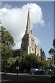
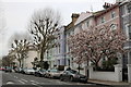
1
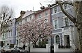
Georgian terrace on Regents Park Road, Primrose Hill
Image: © David Howard
Taken: 21 Mar 2019
0.01 miles
2
Regent's Canal
Seen from the Prince Albert Road Bridge looking towards Camden Town.
Image: © Stephen McKay
Taken: 18 Oct 2007
0.03 miles
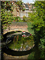
4
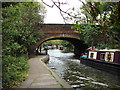
Bridge over the Regent's Canal
This bridge carries Regent's Park Road.
Image: © Oxyman
Taken: 21 Aug 2007
0.03 miles
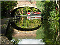
5
Water Meeting Bridge
This bridge carries Prince Albert Road over Regent's Canal close the point at which it meets the Grand Union Canal. On the left stands St Mark's church, only a part of it visible here. A plaque states that the bridge was rebuilt in 1961.
The bridge carrying Regent's Park Road can be seen behind.
Image: © Natasha Ceridwen de Chroustchoff
Taken: 15 Nov 2007
0.04 miles
6
Regent's Canal
This stretch of the Regent's Canal was opened in 1816 as part of a scheme to link Paddington Basin with the River Thames at Limehouse. It was named after the Prince Regent, later George IV, who was friendly with John Nash, a director of the canal company. In 1929, as a result of a series of mergers, the canal became part of the Grand Union Canal Company whose system stretched from London to Birmingham. This view is looking towards Camden Town with Regent's Park Road Bridge ahead.
Image: © Stephen McKay
Taken: 18 Oct 2007
0.04 miles
7
Cecil Sharp House
Headquarters of the English Folk Dance and Song Society.
Image: © Peter Trimming
Taken: 25 Apr 2017
0.04 miles
8
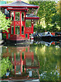
Cumberland Basin
After skirting the northern side of Regent's Park, the Regent's Canal takes a right angle bend to the left heading towards Camden Town. A few yards of canal continue straight on to form Cumberland Basin, home to this floating Chinese restaurant - surely, one of the most astonishing sites anywhere on the canal network.
Image: © Stephen McKay
Taken: 18 Oct 2007
0.04 miles
9
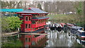
Cumberland Turn, Regent's Canal
The Regent's Canal passes Regent's Park Zoo, and turns left at this junction. The Feng Shang Floating Restaurant can be seen in the middle-distance.
Image: © Peter Trimming
Taken: 26 Feb 2009
0.04 miles