IMAGES TAKEN NEAR TO
Marylebone Road, LONDON, NW1 6JQ
Introduction
This page details the photographs taken nearby to Marylebone Road, NW1 6JQ by members of the Geograph project.
The Geograph project started in 2005 with the aim of publishing, organising and preserving representative images for every square kilometre of Great Britain, Ireland and the Isle of Man.

There are currently over 7.5m images from over14,400 individuals and you can help contribute to the project by visiting https://www.geograph.org.uk
Image Map
Images are licensed for reuse under creativecommons.org/licenses/by-sa/2.0
Notes
- Clicking on the map will re-center to the selected point.
- The higher the marker number, the further away the image location is from the centre of the postcode.
Image Listing (1067 Images Found)
Images are licensed for reuse under creativecommons.org/licenses/by-sa/2.0
Image
Details
Distance
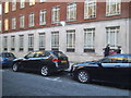
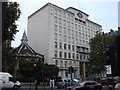
2
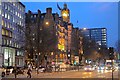
On Marylebone Road
Clock tower of the Landmark Hotel, adjacent to Marylebone Station. The hotel started life at the end of the 19th century to serve travellers on the Great Central Line into Marylebone from Sheffield, Nottingham and Leicester. Currently a 5 star member of the international Landmark Group.
Image: © Anthony O'Neil
Taken: 16 Feb 2017
0.01 miles
3
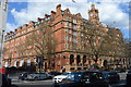
St Marylebone Grammar School
Grade II listed. http://www.britishlistedbuildings.co.uk/en-418103-st-marylebone-grammar-school-greater-lon
Image: © N Chadwick
Taken: 17 Apr 2016
0.02 miles
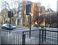
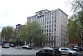
4
Harewood Avenue at the junction of Marylebone Road
Image: © David Howard
Taken: 1 Mar 2014
0.02 miles
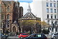
5
The Landmark Hotel
Grade II listed. http://www.britishlistedbuildings.co.uk/en-418101-222-marylebone-road-nw1-greater-london-a
Image: © N Chadwick
Taken: 17 Apr 2016
0.02 miles
7
The old St Marylebone Grammar School on Marylebone Road
The school was built in 1792 as the Philological School and closed in 1981. The right hand part was listed and remains as Abercorn School, with the left part demolished for the current office block.
Image: © David Howard
Taken: 1 Mar 2014
0.02 miles
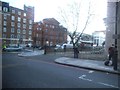
8
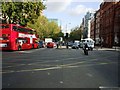
Marylebone Road, NW1
Marylebone Road (A501), junction with Lisson Grove and Seymour Place, part of the Inner London Ring Road that includes Park Lane, Tower Bridge, Vauxhall Bridge.
Image: © Phillip Perry
Taken: 28 Oct 2008
0.02 miles
10
Marylebone Grammar School
Grade II listed. http://www.britishlistedbuildings.co.uk/en-418103-st-marylebone-grammar-school-248-maryleb
Image: © N Chadwick
Taken: 16 Apr 2011
0.03 miles