IMAGES TAKEN NEAR TO
The Drive, LONDON, NW11 9UL
Introduction
This page details the photographs taken nearby to The Drive, NW11 9UL by members of the Geograph project.
The Geograph project started in 2005 with the aim of publishing, organising and preserving representative images for every square kilometre of Great Britain, Ireland and the Isle of Man.

There are currently over 7.5m images from over14,400 individuals and you can help contribute to the project by visiting https://www.geograph.org.uk
Image Map (Loading...)


Getting Data...Please wait
Leaflet Map data © OpenStreetMap
Images are licensed for reuse under creativecommons.org/licenses/by-sa/2.0
Notes
- Clicking on the map will re-center to the selected point.
- The higher the marker number, the further away the image location is from the centre of the postcode.
Image Listing (227 Images Found)
Images are licensed for reuse under creativecommons.org/licenses/by-sa/2.0
Image
Details
Distance
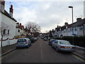
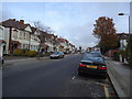
4
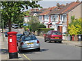
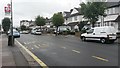
The Drive, NW11 (2)
With a George V postbox at the junction with Elmcroft Crescent.
Image: © Mike Quinn
Taken: 3 Aug 2011
0.05 miles
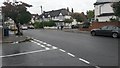
5
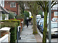
Walking on Shabbat, St Mary's Road, NW11
Going to or from a synagogue in rain garb. There are many synagogues and several orthodox ones in this area.
Image: © Robin Webster
Taken: 26 Feb 2011
0.06 miles
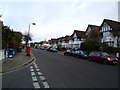
7
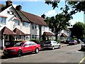
St Marys Rd
St Mary’s Rd Brent Cross. These houses are typical of those built during the 1920 & 30’s as London’s suburbs grew.
Image: © Glyn Baker
Taken: 17 Sep 2005
0.06 miles