IMAGES TAKEN NEAR TO
The Ridgeway, LONDON, NW11 9RX
Introduction
This page details the photographs taken nearby to The Ridgeway, NW11 9RX by members of the Geograph project.
The Geograph project started in 2005 with the aim of publishing, organising and preserving representative images for every square kilometre of Great Britain, Ireland and the Isle of Man.

There are currently over 7.5m images from over14,400 individuals and you can help contribute to the project by visiting https://www.geograph.org.uk
Image Map (Loading...)


Getting Data...Please wait
Leaflet Map data © OpenStreetMap
Images are licensed for reuse under creativecommons.org/licenses/by-sa/2.0
Notes
- Clicking on the map will re-center to the selected point.
- The higher the marker number, the further away the image location is from the centre of the postcode.
Image Listing (120 Images Found)
Images are licensed for reuse under creativecommons.org/licenses/by-sa/2.0
Image
Details
Distance
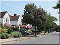
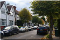
4
The Ridgeway, NW11 (2)
With a George V postbox at its junction with Ridge Hill.
Image: © Mike Quinn
Taken: 3 Aug 2011
0.07 miles
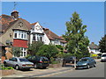
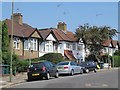
5
Powis Gardens, NW11
A cul-de-sac of semi-detached houses developed very shortly before the First World War.
Image: © Christopher Hilton
Taken: 7 Nov 2016
0.08 miles
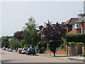
6
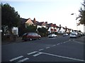
Woodstock Road at the junction of The Drive
Image: © David Howard
Taken: 24 Sep 2014
0.08 miles
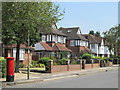
7
Houses on Wessex Gardens, Golders Green
Image: © David Howard
Taken: 13 Aug 2013
0.09 miles
9
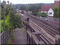
Train approaching the bridge on Woodstock Road (1)
Image: © David Howard
Taken: 13 Aug 2013
0.10 miles
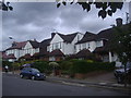
10
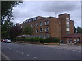
Sunridge Court, The Ridgeway, Golders Green
Image: © David Howard
Taken: 13 Aug 2013
0.10 miles