IMAGES TAKEN NEAR TO
Courtleigh Gardens, LONDON, NW11 9JX
Introduction
This page details the photographs taken nearby to Courtleigh Gardens, NW11 9JX by members of the Geograph project.
The Geograph project started in 2005 with the aim of publishing, organising and preserving representative images for every square kilometre of Great Britain, Ireland and the Isle of Man.

There are currently over 7.5m images from over14,400 individuals and you can help contribute to the project by visiting https://www.geograph.org.uk
Image Map (Loading...)


Getting Data...Please wait
Leaflet Map data © OpenStreetMap
Images are licensed for reuse under creativecommons.org/licenses/by-sa/2.0
Notes
- Clicking on the map will re-center to the selected point.
- The higher the marker number, the further away the image location is from the centre of the postcode.
Image Listing (103 Images Found)
Images are licensed for reuse under creativecommons.org/licenses/by-sa/2.0
Image
Details
Distance
1
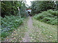
The Capital Ring following Brookside Walk
The Capital Ring follows Brookside Walk, so named after the Mutton Brook which is immediately to the left here.
The Mutton Brook rises near Highgate Wood and flows into the Dollis Brook, which then becomes the River Brent. Much of the Mutton Brook flows in culvert through formal gardens but there are also some more natural sections.
The busy and noisy North Circular Road passes over the Capital Ring and Mutton Brook just ahead - see http://www.geograph.org.uk/photo/4700577
One other point of interest is that this was the furthest point south reached by any of the recent Ice Ages in Britain (the Anglian around 400,000 years ago). Gravel hereabouts has been found to contain stones carried by the ice from as far away as Scandinavia. The Mutton and Dollis Brooks are remnants of periglacial features which were the means by which melt water was conveyed to the River Brent and thence to the Thames at Brentford.
Image: © Marathon
Taken: 14 Oct 2015
0.03 miles
2
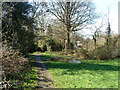
Brookside Walk
A linear park along the Mutton Brook, off to the left. The path is used by the Capital Ring long distance path around London.
Image: © Robin Webster
Taken: 19 Mar 2011
0.04 miles
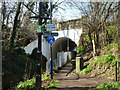
3
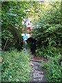
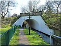
Bridge over Mutton Brook
Mutton Brook and the Brookside Walk pass under the A406 North Circular Road at this point. Cycling and pedestrians are permitted. The path on the right leads up to the North Circular.
Image: © Martin Addison
Taken: 1 Jun 2007
0.04 miles
4
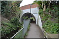
North Circular Bridge over Mutton Brook and Capital Ring
Image: © N Chadwick
Taken: 13 Apr 2017
0.04 miles
5
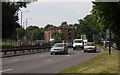
A406 - North Circular Road
Mid morning on a Saturday and the traffic is quite light by A406 standards. This view taken from the corner of Southbourne Crescent. The bridge parapet on the extreme right is where Mutton Brook passes under the road in a tunnel, see Image
Image: © Martin Addison
Taken: 26 Jul 2008
0.05 miles
6
Bridge over Mutton Brook
The brook and the path that follows it squeeze together under the North Circular Road (A406). The black pole in the foreground supports a CCTV camera (extreme top left) keeping an eye on goings-on under the bridge.
Image: © Robin Webster
Taken: 19 Mar 2011
0.05 miles
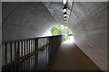
7
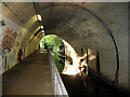
Under the North Circular
Mutton Brook and the Brookside Walk pass under the A406. The graffiti artists have been busy and there is some unpleasant fluid flowing across the footpath. The brook itself is signposted as polluted along its length.
Image: © Martin Addison
Taken: 1 Jun 2007
0.05 miles
8
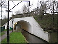
Mutton Brook in Hendon
Mutton Brook eventually merges with Dollis Brook to form the River Brent. It is seen here looking upstream through the A406 North Circular Road Bridge. A post-mounted CCTV camera tries to ensure that using the walkway through the bridge is a more pleasant experience than that which might have prevailed when Martin took his Image inside the bridge in 2007.
Image: © Nigel Cox
Taken: 20 Feb 2011
0.06 miles
9
Bridge over Mutton Brook
The brook and the path that follows it squeeze together under the North Circular Road (A406). The black gallows structure supports a CCTV camera keeping an eye on goings-on under the bridge.
Image: © Robin Webster
Taken: 19 Mar 2011
0.06 miles
10
Capital Ring under the North Circular Road
Image: © N Chadwick
Taken: 13 Apr 2017
0.06 miles