IMAGES TAKEN NEAR TO
Montpelier Rise, LONDON, NW11 9DU
Introduction
This page details the photographs taken nearby to Montpelier Rise, NW11 9DU by members of the Geograph project.
The Geograph project started in 2005 with the aim of publishing, organising and preserving representative images for every square kilometre of Great Britain, Ireland and the Isle of Man.

There are currently over 7.5m images from over14,400 individuals and you can help contribute to the project by visiting https://www.geograph.org.uk
Image Map (Loading...)


Getting Data...Please wait
Leaflet Map data © OpenStreetMap
Images are licensed for reuse under creativecommons.org/licenses/by-sa/2.0
Notes
- Clicking on the map will re-center to the selected point.
- The higher the marker number, the further away the image location is from the centre of the postcode.
Image Listing (164 Images Found)
Images are licensed for reuse under creativecommons.org/licenses/by-sa/2.0
Image
Details
Distance
3
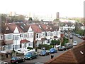
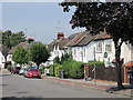
Elmscroft Crescent
Looking from a Jubilee line train.
Image: © Oast House Archive
Taken: 15 Apr 2012
0.04 miles
8
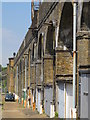
Underground viaduct
Carries the Northern Line (Edgware Branch) over the valley south of Brent Cross station.
Image: © Mike Quinn
Taken: 3 Aug 2011
0.05 miles
10

Electricity Supply
An interesting substation located beside the A41 Hendon Way. I don't know if the building itself still has a function. The sub-station rectifiers are located behind.
Image: © Martin Addison
Taken: 28 May 2010
0.06 miles