IMAGES TAKEN NEAR TO
Montpelier Rise, LONDON, NW11 9DS
Introduction
This page details the photographs taken nearby to Montpelier Rise, NW11 9DS by members of the Geograph project.
The Geograph project started in 2005 with the aim of publishing, organising and preserving representative images for every square kilometre of Great Britain, Ireland and the Isle of Man.

There are currently over 7.5m images from over14,400 individuals and you can help contribute to the project by visiting https://www.geograph.org.uk
Image Map (Loading...)


Getting Data...Please wait
Leaflet Map data © OpenStreetMap
Images are licensed for reuse under creativecommons.org/licenses/by-sa/2.0
Notes
- Clicking on the map will re-center to the selected point.
- The higher the marker number, the further away the image location is from the centre of the postcode.
Image Listing (128 Images Found)
Images are licensed for reuse under creativecommons.org/licenses/by-sa/2.0
Image
Details
Distance
1
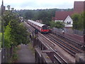
Train approaching the bridge on Woodstock Road (2)
You can just see the platform of Brent Cross station at the end of the line, once called Brent until the shopping centre was built in 1976. It's actually quite a long walk to the station, crossing various major roads by bridges, and not easy when carrying shopping.
Image: © David Howard
Taken: 13 Aug 2013
0.03 miles
2
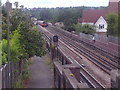
Train approaching the bridge on Woodstock Road (1)
Image: © David Howard
Taken: 13 Aug 2013
0.04 miles