IMAGES TAKEN NEAR TO
Temple Fortune Hill, LONDON, NW11 7XL
Introduction
This page details the photographs taken nearby to Temple Fortune Hill, NW11 7XL by members of the Geograph project.
The Geograph project started in 2005 with the aim of publishing, organising and preserving representative images for every square kilometre of Great Britain, Ireland and the Isle of Man.

There are currently over 7.5m images from over14,400 individuals and you can help contribute to the project by visiting https://www.geograph.org.uk
Image Map (Loading...)


Getting Data...Please wait
Leaflet Map data © OpenStreetMap
Images are licensed for reuse under creativecommons.org/licenses/by-sa/2.0
Notes
- Clicking on the map will re-center to the selected point.
- The higher the marker number, the further away the image location is from the centre of the postcode.
Image Listing (323 Images Found)
Images are licensed for reuse under creativecommons.org/licenses/by-sa/2.0
Image
Details
Distance
2
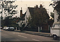
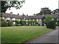
Storm damage on Temple Fortune Hill, Hampstead Garden Suburb
Following the storm in October 1987
Image: © David Howard
Taken: 16 Oct 1987
0.03 miles

5
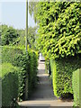
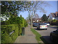
Path to The Orchard, off Willifield Way, NW11
Image: © Mike Quinn
Taken: 3 Aug 2011
0.05 miles
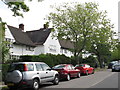
7
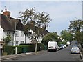
Willifield Way, NW11 (3)
North of its junction with Temple Fortune Hill.
Image: © Mike Quinn
Taken: 3 Aug 2011
0.06 miles
8
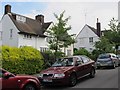
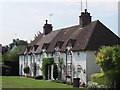
Temple Fortune Hill, Hampstead Garden Suburb
Image: © David Howard
Taken: 29 Mar 2012
0.06 miles
10
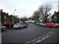
Hampstead Way NW11 at the junction with Temple Fortune Hill NW11
Image: © Robin Sones
Taken: 25 Jan 2010
0.06 miles