IMAGES TAKEN NEAR TO
Linnell Drive, LONDON, NW11 7LP
Introduction
This page details the photographs taken nearby to Linnell Drive, NW11 7LP by members of the Geograph project.
The Geograph project started in 2005 with the aim of publishing, organising and preserving representative images for every square kilometre of Great Britain, Ireland and the Isle of Man.

There are currently over 7.5m images from over14,400 individuals and you can help contribute to the project by visiting https://www.geograph.org.uk
Image Map
Images are licensed for reuse under creativecommons.org/licenses/by-sa/2.0
Notes
- Clicking on the map will re-center to the selected point.
- The higher the marker number, the further away the image location is from the centre of the postcode.
Image Listing (348 Images Found)
Images are licensed for reuse under creativecommons.org/licenses/by-sa/2.0
Image
Details
Distance
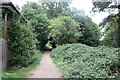
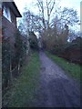
1
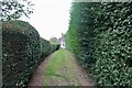
Path from Linnell Close to Linnell Drive
Image: © David Howard
Taken: 11 Sep 2021
0.02 miles
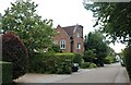
2
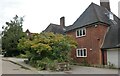
House on Linnell Drive, Hampstead Garden Suburb
Image: © David Howard
Taken: 11 Sep 2021
0.02 miles
3
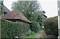
Path from Linnell Drive to Linell Close
Image: © David Howard
Taken: 11 Sep 2021
0.02 miles
4
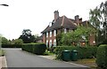
Linnell Close, Hampstead Garden Suburb
Image: © David Howard
Taken: 11 Sep 2021
0.04 miles
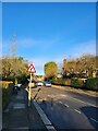
5

Hampstead Way
Cottage style housing on Hampstead Way. The yellow van is crossing the mini-roundabout at the junction with Meadway.
Image: © Martin Addison
Taken: 3 Sep 2008
0.05 miles
6
Linnell Close, Hampstead Garden Suburb
Image: © David Howard
Taken: 11 Sep 2021
0.06 miles
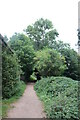
10
Path along the edge of Hampstead Heath Extension
Image: © David Howard
Taken: 14 Jan 2014
0.06 miles