IMAGES TAKEN NEAR TO
Oakwood Road, LONDON, NW11 6QY
Introduction
This page details the photographs taken nearby to Oakwood Road, NW11 6QY by members of the Geograph project.
The Geograph project started in 2005 with the aim of publishing, organising and preserving representative images for every square kilometre of Great Britain, Ireland and the Isle of Man.

There are currently over 7.5m images from over14,400 individuals and you can help contribute to the project by visiting https://www.geograph.org.uk
Image Map (Loading...)


Getting Data...Please wait
Leaflet Map data © OpenStreetMap
Images are licensed for reuse under creativecommons.org/licenses/by-sa/2.0
Notes
- Clicking on the map will re-center to the selected point.
- The higher the marker number, the further away the image location is from the centre of the postcode.
Image Listing (174 Images Found)
Images are licensed for reuse under creativecommons.org/licenses/by-sa/2.0
Image
Details
Distance
1
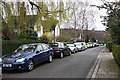
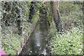
Denman Drive North
Looking towards Oakwood Road and into the valley of Mutton Brook. The treeline in the distance is the high ground around Marylebone Crematorium and East End Road.
Image: © Martin Addison
Taken: 24 Mar 2008
0.03 miles
2
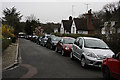
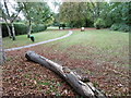
Denman Drive South
Looking from the corner towards Oakwood Road. Spring flowers add a touch of colour on a very grey morning
Image: © Martin Addison
Taken: 24 Mar 2008
0.04 miles
4
Denman Drive North and Little Wood
The corner of Denman Drive North showing the footpath entrance to Little Wood. The road and footpath form part of the Dollis Valley Green Walk as it routes to Big Wood and subsequently Hampstead Heath.
Image: © Martin Addison
Taken: 24 Mar 2008
0.06 miles
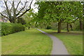
5
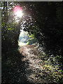
Footpath by Mutton Brook
The sun brightens a chilly November morning in Hampstead Garden Suburb.
Image: © Martin Addison
Taken: 4 Nov 2006
0.06 miles
6
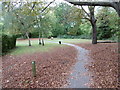
The Capital Ring and Mutton Brook in Northway Gardens
Northway Gardens was laid out as part of the 'New Suburb' developed from 1911 when 112 acres of land were purchased to the east of the original Hampstead Garden Suburb - see http://www.londongardensonline.org.uk/gardens-online-record.asp?ID=BAR057 and https://en.wikipedia.org/wiki/Hampstead_Garden_Suburb
The Mutton Brook follows the southern boundary of Northway Gardens and flows between the trees seen on the right. The Mutton Brook rises near Highgate Wood and flows into the Dollis Brook, which then becomes the River Brent. Much of the Mutton Brook flows in culvert through formal gardens but there are also some more natural sections.
This is the view from near the entrance to Northway Gardens from Falloden Way, which is the busy and noisy A1.
Image: © Marathon
Taken: 14 Oct 2015
0.06 miles
7
The Capital Ring in Northway Gardens
Northway Gardens was laid out as part of the 'New Suburb' developed from 1911 when 112 acres of land were purchased to the east of the original Hampstead Garden Suburb - see http://www.londongardensonline.org.uk/gardens-online-record.asp?ID=BAR057 and https://en.wikipedia.org/wiki/Hampstead_Garden_Suburb
The Mutton Brook follows the southern boundary of Northway Gardens and flows between the trees seen ahead. The Mutton Brook rises near Highgate Wood and flows into the Dollis Brook, which then becomes the River Brent. Much of the Mutton Brook flows in culvert through formal gardens but there are also some more natural sections.
This is the view from the entrance to Northway Gardens from Falloden Way which is the busy and noisy A1.
Image: © Marathon
Taken: 14 Oct 2015
0.06 miles
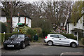
9
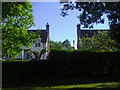
Backs of houses on Oakwood Road from Northway Gardens
Unlike most houses designed by builders the backs of the houses in Hampstead Garden Suburb are given as much attention to detail as the fronts. In fact with these it would be difficult to see the difference.
Image: © David Howard
Taken: 23 May 2013
0.07 miles
10
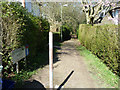
Path to Little Wood
From Denman Drive North.
Image: © Robin Webster
Taken: 19 Mar 2011
0.07 miles