IMAGES TAKEN NEAR TO
Meadway, LONDON, NW11 6QH
Introduction
This page details the photographs taken nearby to Meadway, NW11 6QH by members of the Geograph project.
The Geograph project started in 2005 with the aim of publishing, organising and preserving representative images for every square kilometre of Great Britain, Ireland and the Isle of Man.

There are currently over 7.5m images from over14,400 individuals and you can help contribute to the project by visiting https://www.geograph.org.uk
Image Map
Images are licensed for reuse under creativecommons.org/licenses/by-sa/2.0
Notes
- Clicking on the map will re-center to the selected point.
- The higher the marker number, the further away the image location is from the centre of the postcode.
Image Listing (132 Images Found)
Images are licensed for reuse under creativecommons.org/licenses/by-sa/2.0
Image
Details
Distance

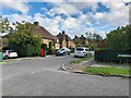
2
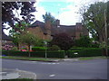
House on the corner of Meadway and Grey Close
Image: © David Howard
Taken: 22 May 2013
0.03 miles
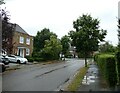
3
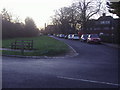
Kingsley Way junction with Neville Drive
Image: © David Howard
Taken: 1 Jan 2010
0.04 miles
4
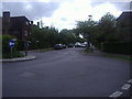
Meadway at the junction of Litchfield Way
Image: © David Howard
Taken: 22 May 2013
0.04 miles
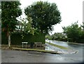
5
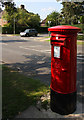
Pillar Box on Holne Chase.
This pillar box looks brand new. Behind is the junction with Kinglsey Way.
Image: © Martin Addison
Taken: 30 Aug 2008
0.05 miles
7
Golders Green to East Finchley (129)
Approaching the junction of Linden Lea and Kingsley Way
Image: © Basher Eyre
Taken: 24 Aug 2024
0.08 miles
8
Golders Green to East Finchley (130)
Junction of Linden Lea and Kingsley Way
Image: © Basher Eyre
Taken: 24 Aug 2024
0.09 miles

10
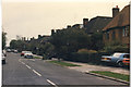
Storm damage on Meadway, Hampstead Garden Suburb
Following the storm on October the 16th 1987
Image: © David Howard
Taken: 16 Oct 1987
0.10 miles