IMAGES TAKEN NEAR TO
Hill Top, LONDON, NW11 6EE
Introduction
This page details the photographs taken nearby to Hill Top, NW11 6EE by members of the Geograph project.
The Geograph project started in 2005 with the aim of publishing, organising and preserving representative images for every square kilometre of Great Britain, Ireland and the Isle of Man.

There are currently over 7.5m images from over14,400 individuals and you can help contribute to the project by visiting https://www.geograph.org.uk
Image Map (Loading...)


Getting Data...Please wait
Leaflet Map data © OpenStreetMap
Images are licensed for reuse under creativecommons.org/licenses/by-sa/2.0
Notes
- Clicking on the map will re-center to the selected point.
- The higher the marker number, the further away the image location is from the centre of the postcode.
Image Listing (344 Images Found)
Images are licensed for reuse under creativecommons.org/licenses/by-sa/2.0
Image
Details
Distance
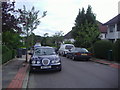
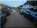
1
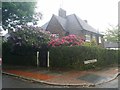
House on the corner of Hill Top and Hutchings Walk
Image: © David Howard
Taken: 1 Jun 2018
0.03 miles
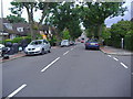
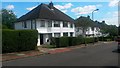
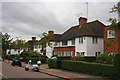
3
Houses on Hill Top, Hampstead Garden Suburb
I walked past these on the way to and from school from 1965-9
Image: © David Howard
Taken: 30 Jun 2006
0.04 miles
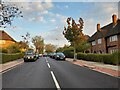
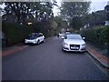
4
Hutchings Walk NW11
One of a number of art deco roads in Hampstead Garden Suburb
Image: © David Howard
Taken: 18 Jun 2008
0.05 miles
6
Hutchings Walk, Hampstead Garden Suburb
Image: © David Howard
Taken: 12 Oct 2023
0.05 miles
7
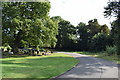
St Marylebone Cemetery
Towards the southern end of the cemetery.
Image: © Trevor Harris
Taken: 7 Sep 2016
0.05 miles
8
Hutchings Walk, Hampstead Garden Suburb
Image: © David Howard
Taken: 12 Oct 2023
0.06 miles
9
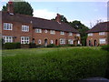
Hill Rise
Semi-detached housing on Hill Rise. The brickwork ground floor sections are unusual.
Image: © Martin Addison
Taken: 25 Aug 2008
0.08 miles