IMAGES TAKEN NEAR TO
Harmony Close, LONDON, NW11 0JJ
Introduction
This page details the photographs taken nearby to Harmony Close, NW11 0JJ by members of the Geograph project.
The Geograph project started in 2005 with the aim of publishing, organising and preserving representative images for every square kilometre of Great Britain, Ireland and the Isle of Man.

There are currently over 7.5m images from over14,400 individuals and you can help contribute to the project by visiting https://www.geograph.org.uk
Image Map (Loading...)


Getting Data...Please wait
Leaflet Map data © OpenStreetMap
Images are licensed for reuse under creativecommons.org/licenses/by-sa/2.0
Notes
- Clicking on the map will re-center to the selected point.
- The higher the marker number, the further away the image location is from the centre of the postcode.
Image Listing (114 Images Found)
Images are licensed for reuse under creativecommons.org/licenses/by-sa/2.0
Image
Details
Distance
1
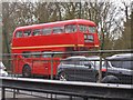
A bus out of place
This was not a 25 from Ilford to Victoria but a charter in Golders Green
Image: © David Howard
Taken: 15 Apr 2018
0.09 miles
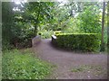
2
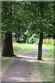
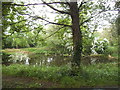
Walking the Dog
View of the footpath through Brent Park.
Image: © Martin Addison
Taken: 26 Jul 2008
0.10 miles
3
Brent Park, Hendon
Just by the North Circular Road behind the fence
Image: © David Howard
Taken: 10 Mar 2015
0.10 miles
4

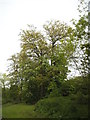
Dying Oak
Although the tree is still in leaf, the rot has clearly set in and it is only a matter of time before the parks team break out the chainsaws.
Image: © Martin Addison
Taken: 26 Jul 2008
0.10 miles
6
Trees in Brent Park, Golders Green
At some point they moved the border from Hendon to Golders Green from the North Circular Road on the right to the River Brent on the left, meaning this strip between was shifted into Golders Green, and also changed the name of Bell Lane to Bridge Lane for that part, even though the dual carriageway makes it impossible to travel from one part to the other.
Image: © David Howard
Taken: 1 May 2014
0.11 miles
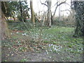
7
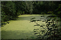
Brent Park
At the south end of the lake. This section is connected to the main lake by a narrow strip of water. The surface is completely covered with duckweed. The trails have been left by moorhens.
Image: © Martin Addison
Taken: 26 Jul 2008
0.11 miles
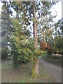
9
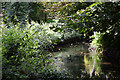
River Brent
Horse Chestnut and Nettles overhang the river near the southern end of Brent Park.
Image: © Martin Addison
Taken: 26 Jul 2008
0.12 miles
10
Bridge over drainage ditch, Brent Park
The ditch drains from the Decoy pond on the right behind the hedge
Image: © David Howard
Taken: 25 Jun 2013
0.12 miles