IMAGES TAKEN NEAR TO
Hurstwood Road, LONDON, NW11 0AS
Introduction
This page details the photographs taken nearby to Hurstwood Road, NW11 0AS by members of the Geograph project.
The Geograph project started in 2005 with the aim of publishing, organising and preserving representative images for every square kilometre of Great Britain, Ireland and the Isle of Man.

There are currently over 7.5m images from over14,400 individuals and you can help contribute to the project by visiting https://www.geograph.org.uk
Image Map (Loading...)


Getting Data...Please wait
Leaflet Map data © OpenStreetMap
Images are licensed for reuse under creativecommons.org/licenses/by-sa/2.0
Notes
- Clicking on the map will re-center to the selected point.
- The higher the marker number, the further away the image location is from the centre of the postcode.
Image Listing (219 Images Found)
Images are licensed for reuse under creativecommons.org/licenses/by-sa/2.0
Image
Details
Distance
1
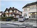
Houses on Hurstwood Road, Temple Fortune
Image: © David Howard
Taken: 29 Jun 2022
0.02 miles
2
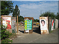
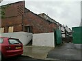
Henlys Garage
The mortal remains of Henlys Garage. Rubble, 2 discarded trucks, a skip and some shopping trolleys hide behind boarding. Once a thriving business that gave its name to a major road junction.
Image: © Martin Addison
Taken: 17 Jun 2006
0.05 miles
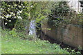
4
Sloping tree by Mutton Brook, Hampstead Garden Suburb
Image: © David Howard
Taken: 29 Jun 2022
0.06 miles
6

Pink bike in Monkville Avenue
Eye-catching piece of work chained outside the parquet Flooring premises.
Image: © Ian Paterson
Taken: 28 Apr 2011
0.06 miles
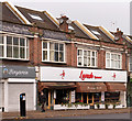
7
Rear of shops on Finchley Road, Temple Fortune
From Hurstwood Road
Image: © David Howard
Taken: 23 May 2021
0.06 miles
8
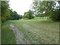
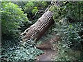
The Capital Ring following Brookside Walk
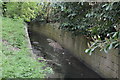
The Capital Ring follows Brookside Walk, so named after the Mutton Brook which is to the left here.
The Mutton Brook rises near Highgate Wood and flows into the Dollis Brook, which then becomes the River Brent. Much of the Mutton Brook flows in culvert through formal gardens but there are also some more natural sections.
The busy and noisy North Circular Road is to the right here at the top of the slope.
One other point of interest is that this was the furthest point south reached by any of the recent Ice Ages in Britain (the Anglian around 400,000 years ago). Gravel hereabouts has been found to contain stones carried by the ice from as far away as Scandinavia. The Mutton and Dollis Brooks are remnants of periglacial features which were the means by which melt water was conveyed to the River Brent and thence to the Thames at Brentford.
Image: © Marathon
Taken: 14 Oct 2015
0.07 miles
9
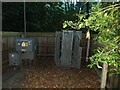
Addison Way electricity transformer, Hampstead Garden Suburb
Image: © David Howard
Taken: 29 Jun 2022
0.07 miles
10
Lavash Restaurant, Finchley Road - November 2016
A Persian restaurant on the Finchley Road.
Photograph is for record only - I have no connection with this business and cannot advise on its products or services.
Image: © The Carlisle Kid
Taken: 10 Nov 2016
0.07 miles