IMAGES TAKEN NEAR TO
Rigeley Road, LONDON, NW10 6AR
Introduction
This page details the photographs taken nearby to Rigeley Road, NW10 6AR by members of the Geograph project.
The Geograph project started in 2005 with the aim of publishing, organising and preserving representative images for every square kilometre of Great Britain, Ireland and the Isle of Man.

There are currently over 7.5m images from over14,400 individuals and you can help contribute to the project by visiting https://www.geograph.org.uk
Image Map (Loading...)


Getting Data...Please wait
Leaflet Map data © OpenStreetMap
Images are licensed for reuse under creativecommons.org/licenses/by-sa/2.0
Notes
- Clicking on the map will re-center to the selected point.
- The higher the marker number, the further away the image location is from the centre of the postcode.
Image Listing (118 Images Found)
Images are licensed for reuse under creativecommons.org/licenses/by-sa/2.0
Image
Details
Distance
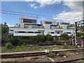
2
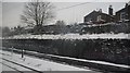
Railway cutting, west Coast Main Line, College Green
Image: © N Chadwick
Taken: 19 Dec 2010
0.05 miles
3
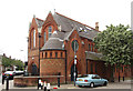
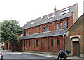
St Jude, Kenmont Gardens
Now St Jude's Social Club
Image: © John Salmon
Taken: 23 May 2014
0.06 miles
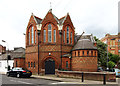
5
St Jude, Kenmont Gardens
Now St Jude's Social Club
Image: © John Salmon
Taken: 23 May 2014
0.06 miles
6
St Jude, Kenmont Gardens
Now St Jude's Social Club
Image: © John Salmon
Taken: 23 May 2014
0.06 miles
8
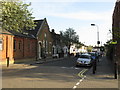
Waldo Road, off Scrubs Lane
With the junction with Letchford Gardens in the distance.
Image: © Christine Johnstone
Taken: 28 Feb 2012
0.06 miles
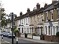
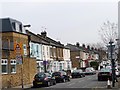
10
Houses on Scrubs Lane, College Park
I had a friend who lived in the flats opposite here who told me the name of the area. The building on the left was a pub from memory.
Image: © David Howard
Taken: 22 Jul 2014
0.07 miles