IMAGES TAKEN NEAR TO
Donnington Road, LONDON, NW10 3QX
Introduction
This page details the photographs taken nearby to Donnington Road, NW10 3QX by members of the Geograph project.
The Geograph project started in 2005 with the aim of publishing, organising and preserving representative images for every square kilometre of Great Britain, Ireland and the Isle of Man.

There are currently over 7.5m images from over14,400 individuals and you can help contribute to the project by visiting https://www.geograph.org.uk
Image Map (Loading...)


Getting Data...Please wait
Leaflet Map data © OpenStreetMap
Images are licensed for reuse under creativecommons.org/licenses/by-sa/2.0
Notes
- Clicking on the map will re-center to the selected point.
- The higher the marker number, the further away the image location is from the centre of the postcode.
Image Listing (40 Images Found)
Images are licensed for reuse under creativecommons.org/licenses/by-sa/2.0
Image
Details
Distance
1
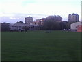
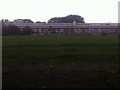
Flats by King Edward VII Park
Capital Academy is on the left and Willesden Sports Centre is on the right of the flats.
Image: © David Howard
Taken: 9 Oct 2013
0.03 miles
2
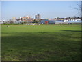
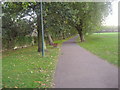
Willesden Sports Centre
Looking across the pitches to the Willesden Sports Centre
Image: © Shaun Ferguson
Taken: 1 Apr 2009
0.04 miles
3
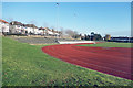
Athletics Track, Willesden Sports Centre
Image: © Des Blenkinsopp
Taken: 20 Jan 2020
0.08 miles
4
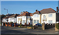
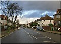
Houses on Donnington Road
Suburban housing with some added balconies overlooking the open space of Willesden Sports Centre.
Image: © Des Blenkinsopp
Taken: 20 Jan 2020
0.09 miles
5
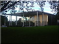
Capital Academy, Willesden
From King Edward VII Park
Image: © David Howard
Taken: 9 Oct 2013
0.09 miles
6
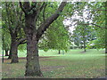
King Edward VII Park, Willesden
During WW2 the park was largely filled with sand which was presumably wanted for anti-bomb blast sandbags and for putting into buckets for fire extinguishing. There was a piggery for home food production. A few years after the war it received hundreds of lorry loads of smelly incinerated refuse which was placed over the sand and created a higher and well drained surface for the park. There was an open-air swimming pool at the NW corner of the park.
(Graham Cole)
Image: © David Howard
Taken: 9 Oct 2013
0.10 miles
7
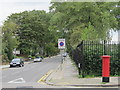
All Souls' Avenue, NW10
Looking NE, toward the distant junction with Chamberlayne Road and Sidmouth Road. The turning on the right, a short way ahead, is Leighton Gardens. Typical between-the-wars residential development - seen on Christmas Day, 2012.
Image: © Stefan Czapski
Taken: 25 Dec 2012
0.13 miles
9
Uffington Road, NW10 (2)
Shows the location of Image
Image: © Mike Quinn
Taken: 7 Sep 2011
0.14 miles
10
(Part of) King Edward VII Recreation Ground, Doyle Gardens, NW10
Image: © Mike Quinn
Taken: 7 Sep 2011
0.14 miles