IMAGES TAKEN NEAR TO
Wyborne Way, LONDON, NW10 0TE
Introduction
This page details the photographs taken nearby to Wyborne Way, NW10 0TE by members of the Geograph project.
The Geograph project started in 2005 with the aim of publishing, organising and preserving representative images for every square kilometre of Great Britain, Ireland and the Isle of Man.

There are currently over 7.5m images from over14,400 individuals and you can help contribute to the project by visiting https://www.geograph.org.uk
Image Map (Loading...)


Getting Data...Please wait
Leaflet Map data © OpenStreetMap
Images are licensed for reuse under creativecommons.org/licenses/by-sa/2.0
Notes
- Clicking on the map will re-center to the selected point.
- The higher the marker number, the further away the image location is from the centre of the postcode.
Image Listing (64 Images Found)
Images are licensed for reuse under creativecommons.org/licenses/by-sa/2.0
Image
Details
Distance
1
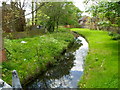
Canal feeder, Twybridge Way, London NW10
Viewed from the bridge carrying Twybridge Way over the water. This channel conveys water from Brent Reservoir to the Grand Union Canal.
Image: © Jaggery
Taken: 13 May 2012
0.04 miles
2
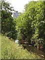
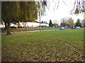
River Brent from Lilburne walk at Tokyngton Recreation Ground
Image: © David Hawgood
Taken: 7 Jun 2005
0.05 miles
3
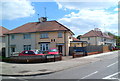
Wyborne Way, London NW10
This is the northern end of the road, viewed from the edge of the North Circular Road (A406).
Image: © Jaggery
Taken: 13 May 2012
0.05 miles
5
Green between Sunny Crescent and Wyborne Way
Image: © David Howard
Taken: 4 Dec 2013
0.08 miles
6
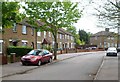
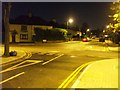
Twybridge Way, London NW10
Viewed from the Conduit Way end.
Image: © Jaggery
Taken: 13 May 2012
0.09 miles
7
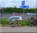
Cycle network distances from Wyborne Way, London NW10
A London Cycle Network signpost on route 85 is located at the northern end of Wyborne Way, alongside the North Circular Road. Distances in miles shown are:
Left for Stonebridge Park (¼ ) and Ealing (3).
Along Wyborne Way for the Hindu Temple http://www.geograph.org.uk/photo/3096697 (½) Neasden (1½) and Barnet (7½).
In the distance is the 134 metre high (440 ft) Wembley Arch. http://www.geograph.org.uk/photo/2406320
Image: © Jaggery
Taken: 13 May 2012
0.09 miles
8
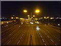
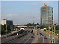
A406 - North Circular Road II, NW10
Looking towards the next junction and underpass which is Harrow Road.
Image: © Phillip Perry
Taken: 12 Nov 2008
0.11 miles
9
A406 North Circular Road near Tokynton
Image: © Gareth James
Taken: 23 Jul 2014
0.11 miles
10
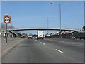
Footbridge over the North Circular Road at Wyborne Way
Image: © Peter Whatley
Taken: 1 Apr 2012
0.12 miles