IMAGES TAKEN NEAR TO
Oxburgh Square, FAKENHAM, NR21 7JP
Introduction
This page details the photographs taken nearby to Oxburgh Square, NR21 7JP by members of the Geograph project.
The Geograph project started in 2005 with the aim of publishing, organising and preserving representative images for every square kilometre of Great Britain, Ireland and the Isle of Man.

There are currently over 7.5m images from over14,400 individuals and you can help contribute to the project by visiting https://www.geograph.org.uk
Image Map
Images are licensed for reuse under creativecommons.org/licenses/by-sa/2.0
Notes
- Clicking on the map will re-center to the selected point.
- The higher the marker number, the further away the image location is from the centre of the postcode.
Image Listing (46 Images Found)
Images are licensed for reuse under creativecommons.org/licenses/by-sa/2.0
Image
Details
Distance
1
The Airmen's Married Quarters at RAF West Raynham
When the airfield closed in 1994 the married quarters were converted into private housing.
Image: © Evelyn Simak
Taken: 1 Nov 2014
0.03 miles
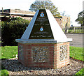
2
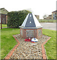
RAF West Raynham airfield memorial
Built between 1938 and 1939, RAF West Raynham was an expansion scheme airfield. The grass landing area was aligned roughly north-east to south-west. The main camp, with housing and headquarters, was located immediately west of the landing area. From 1945 to 1962, RAF West Raynham was Central Fighter Establishment of the Royal Air Force. In 1964, the East side of the airfield was developed as a SAM site, equipped with the Bristol Bloodhound Mk2 and its associated radars. In 1994, RAF West Raynham was shut down by the Ministry of Defence.
See https://www.geograph.org.uk/article/RAF-West-Raynham for the full story
Image: © Adrian S Pye
Taken: 15 Dec 2019
0.06 miles
3
Memorial at RAF West Raynham, Norfolk
Image: © Richard Humphrey
Taken: 3 Dec 2014
0.07 miles
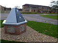
4
RAF West Raynham memorial
The memorial was unveiled on 27 September 2014 and commemorates all the personnel that served at the station. It is situated beside the former NAAFI shop. The buildings seen in the background are Block 35 with the Barracks store behind it. The NAAFI shop can be seen at left. For a more detailed view see > http://www.geograph.org.uk/photo/4228735. For a view of the memorial plaque see > http://www.geograph.org.uk/photo/4228738.
Image: © Evelyn Simak
Taken: 1 Nov 2014
0.07 miles
5
RAF West Raynham memorial
The memorial was unveiled on 27 September 2014 and commemorates all the personnel that served at the station. For a wider view of this location see > http://www.geograph.org.uk/photo/4228734. For a close-up view of the memorial plaque see > http://www.geograph.org.uk/photo/4228738.
Image: © Evelyn Simak
Taken: 1 Nov 2014
0.07 miles
6
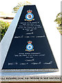
RAF West Raynham memorial (memorial plaque)
The memorial was unveiled on 27 September 2014 and commemorates all the personnel that served at the station. For a wider view of this location see > http://www.geograph.org.uk/photo/4228734. For a full view of the memorial see > http://www.geograph.org.uk/photo/4228735.
Image: © Evelyn Simak
Taken: 1 Nov 2014
0.07 miles
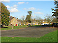
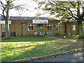
7
Children's playground at The Kiptons
This area was part of the Airmen's Married Quarters of RAF West Raynham before the airfield was closed in 1994.
Image: © Evelyn Simak
Taken: 1 Nov 2014
0.07 miles
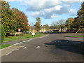
8
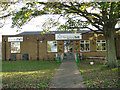
Pub and shop at the Kiptons
This building, which used to be the Ration store, is located just north of the former NAAFI of RAF West Raynham. The airfield's buildings have since been converted to private or industrial uses.
Image: © Evelyn Simak
Taken: 1 Nov 2014
0.08 miles
9
The Kiptons hub and The Pub
This building, which used to be the Ration store, is situated just north of the former NAAFI of RAF West Raynham which was closed in 1994. The airfield's buildings have since been converted to private or industrial uses.
Image: © Evelyn Simak
Taken: 1 Nov 2014
0.08 miles
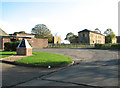
10
Airmen's Married Quarters
After RAF West Raynham was closed in 1994 all these houses were converted into private dwellings.
Image: © Evelyn Simak
Taken: 1 Nov 2014
0.09 miles