IMAGES TAKEN NEAR TO
Eccles, NORWICH, NR16 2NY
Introduction
This page details the photographs taken nearby to NR16 2NY by members of the Geograph project.
The Geograph project started in 2005 with the aim of publishing, organising and preserving representative images for every square kilometre of Great Britain, Ireland and the Isle of Man.

There are currently over 7.5m images from over14,400 individuals and you can help contribute to the project by visiting https://www.geograph.org.uk
Image Map
Images are licensed for reuse under creativecommons.org/licenses/by-sa/2.0
Notes
- Clicking on the map will re-center to the selected point.
- The higher the marker number, the further away the image location is from the centre of the postcode.
Image Listing (18 Images Found)
Images are licensed for reuse under creativecommons.org/licenses/by-sa/2.0
Image
Details
Distance
1
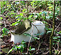
A broken toilet bowl
It has not survived intact on the WAAF Site 2 of RAF Snetterton Heath/USAAF Station 138, which was an active airfield for some time during WW2 > http://www.geograph.org.uk/article/RAF-Snetterton-Heath---USAAF-Station-138.
Image: © Evelyn Simak
Taken: 13 Mar 2017
0.07 miles
2
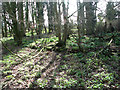
Hut platforms in the woods
WW2 survivors on the WAAF Site 2 of RAF Snetterton Heath/USAAF Station 138, which was an active airfield for some time during WW2 > http://www.geograph.org.uk/article/RAF-Snetterton-Heath---USAAF-Station-138.
Image: © Evelyn Simak
Taken: 13 Mar 2017
0.07 miles
3
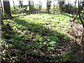
Overgrown hut platform
It has survived on the WAAF Site 2 of RAF Snetterton Heath/USAAF Station 138, which was an active airfield for some time during WW2 > http://www.geograph.org.uk/article/RAF-Snetterton-Heath---USAAF-Station-138.
Image: © Evelyn Simak
Taken: 13 Mar 2017
0.07 miles
4
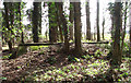
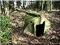
A Stanton air raid shelter from WW2
It has survived on the WAAF Site 2 of RAF Snetterton Heath/USAAF Station 138, which was an active airfield for some time during WW2 > http://www.geograph.org.uk/article/RAF-Snetterton-Heath---USAAF-Station-138.
Image: © Evelyn Simak
Taken: 13 Mar 2017
0.07 miles
5
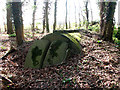
A Stanton air raid shelter
It has survived on the WAAF Site 2 of RAF Snetterton Heath/USAAF Station 138, which was an active airfield for some time during WW2 > http://www.geograph.org.uk/article/RAF-Snetterton-Heath---USAAF-Station-138.
Image: © Evelyn Simak
Taken: 13 Mar 2017
0.07 miles
6
A WW2 Stanton air raid shelter
It has survived on the WAAF Site 2 of RAF Snetterton Heath/USAAF Station 138, which was an active airfield for some time during WW2 > http://www.geograph.org.uk/article/RAF-Snetterton-Heath---USAAF-Station-138.
Image: © Evelyn Simak
Taken: 13 Mar 2017
0.07 miles
7
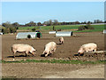
Pigs west of Eccles Common
During WW2, Site 6, one of the accommodation sites of RAF Snetterton Heath which was USAAF Station 138 > http://www.geograph.org.uk/article/RAF-Snetterton-Heath---USAAF-Station-138 was spread out over this field.
Image: © Evelyn Simak
Taken: 13 Mar 2017
0.09 miles
8

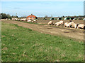
Free range pigs by Manor Farm
During WW2, Site 6, one of the accommodation sites of RAF Snetterton Heath which was USAAF Station 138 > http://www.geograph.org.uk/article/RAF-Snetterton-Heath---USAAF-Station-138 was spread out over this field.
Image: © Evelyn Simak
Taken: 13 Mar 2017
0.10 miles
9
Free range pigs south of Manor Farm
During WW2, Site 6, one of the accommodation sites of RAF Snetterton Heath which was USAAF Station 138 > http://www.geograph.org.uk/article/RAF-Snetterton-Heath---USAAF-Station-138 was spread out over this field.
Image: © Evelyn Simak
Taken: 13 Mar 2017
0.15 miles
10
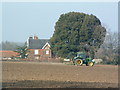
Preparing the land
Preparing the lane ready for a summer crop; Manor Farm in the background near to Quidenham Norfolk.
Image: © Keith Evans
Taken: 27 Mar 2007
0.19 miles