IMAGES TAKEN NEAR TO
Milton Drive, NORWICH, NR14 6FH
Introduction
This page details the photographs taken nearby to Milton Drive, NR14 6FH by members of the Geograph project.
The Geograph project started in 2005 with the aim of publishing, organising and preserving representative images for every square kilometre of Great Britain, Ireland and the Isle of Man.

There are currently over 7.5m images from over14,400 individuals and you can help contribute to the project by visiting https://www.geograph.org.uk
Image Map
Images are licensed for reuse under creativecommons.org/licenses/by-sa/2.0
Notes
- Clicking on the map will re-center to the selected point.
- The higher the marker number, the further away the image location is from the centre of the postcode.
Image Listing (107 Images Found)
Images are licensed for reuse under creativecommons.org/licenses/by-sa/2.0
Image
Details
Distance
1

Marsh pastures in Loddon
The houses seen in the background (in square) are located in Mill Road.
Image: © Evelyn Simak
Taken: 26 Apr 2018
0.08 miles
2

The Pooh Sticks Bridge
A foot bridge over a small steam from the Marshes, great for pooh sticks
Image: © Ashley Dace
Taken: 30 Jan 2010
0.15 miles
3
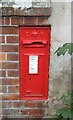
Edward VII postbox on Mill Road, Loddon
Postbox No. NR14 1412.
See Image] for context.
Image: © JThomas
Taken: 20 Sep 2017
0.17 miles
4
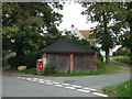
Garages on Mill Road, Loddon
Showing position of Postbox No. NR14 1412.
See Image] postbox.
Image: © JThomas
Taken: 20 Sep 2017
0.17 miles
5

Loddon Marshes
A view from the footpath over the grazing land on Loddon Marshes. Taken on a short walk from Loddon Church to Pies Mill.
Image: © Ashley Dace
Taken: 30 Jan 2010
0.17 miles
6

Tree covered Path
I have known this path since a little boy, a good Poo sticks bridge is in the middle and it is the first place I saw a King Fisher. It links Loddon main street with Mill Lane.
Image: © Ashley Dace
Taken: 30 Jan 2010
0.19 miles
7
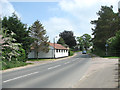
Beccles Road past the Loddon veterinary surgery
Image: © Evelyn Simak
Taken: 28 May 2016
0.19 miles
8

Loddon Church
It was built by the wealthy landowner Sir James Hobart in 1490
Image: © Rog Frost
Taken: 16 Apr 2004
0.20 miles
9

The grave of John Chaston
John Chaston was born on 28 May 1846 and died on 16 June 1899. The stone also commemorates Emma, his wife, who is interred at Ystrad Mynach, Glamorganshire, presumably because she requested it. The epitaph reads:
"Thy will be done"
The grave can be found beside the eastern boundary wall of the cemetery. See > https://www.geograph.org.uk/photo/5753393 for a more detailed view.
Image: © Evelyn Simak
Taken: 26 Apr 2018
0.20 miles
10
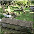
Old graves in Holy Trinity churchyard
The sarcophagus-type stone in the foreground marks the grave of Hannah Susanna Larke, late of Norwich, who died on 24 May 1859. The graves can be found in the south-eastern corner of Holy Trinity churchyard > http://www.geograph.org.uk/photo/5753324.
Image: © Evelyn Simak
Taken: 26 Apr 2018
0.21 miles