IMAGES TAKEN NEAR TO
Bracondale Millgate, NORWICH, NR1 2FB
Introduction
This page details the photographs taken nearby to Bracondale Millgate, NR1 2FB by members of the Geograph project.
The Geograph project started in 2005 with the aim of publishing, organising and preserving representative images for every square kilometre of Great Britain, Ireland and the Isle of Man.

There are currently over 7.5m images from over14,400 individuals and you can help contribute to the project by visiting https://www.geograph.org.uk
Image Map
Images are licensed for reuse under creativecommons.org/licenses/by-sa/2.0
Notes
- Clicking on the map will re-center to the selected point.
- The higher the marker number, the further away the image location is from the centre of the postcode.
Image Listing (265 Images Found)
Images are licensed for reuse under creativecommons.org/licenses/by-sa/2.0
Image
Details
Distance
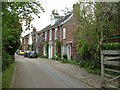
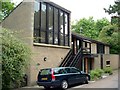
1
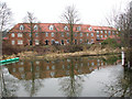
New housing in Millgate
New housing built to resemble old warehouses. It was constructed in 2003 and successfully completes the historic appearance of the mill > http://www.geograph.org.uk/photo/1673444.
Image: © Evelyn Simak
Taken: 21 Jan 2010
0.02 miles
2
New housing in Millgate
New housing built to resemble old warehouses. It was constructed in 2003 and successfully completes the historic appearance of the mill > http://www.geograph.org.uk/photo/1673444.
Image: © Evelyn Simak
Taken: 21 Jan 2010
0.03 miles
3
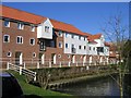
Trowse Mill
The mill was demolished in 1967; what you see today was built recently in a style and layout remarkably sympathetic to the old mill : http://www.norfolkmills.co.uk/Watermills/trowse.html
In the background can be seen the top of Image
Image: © Graham Hardy
Taken: 17 Apr 2006
0.03 miles
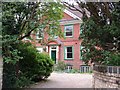
4
Housing resembling Trowse Mill
The mill is mentioned in the Domesday Book but sadly, the original building was demolished. Fortunately, the two tail races as well as the mill pond have survived and the site was redeveloped in 2001, this time for housing. The design was based on the original mill building: http://www.norfolkmills.co.uk/Watermills/trowse.html.
Image: © Evelyn Simak
Taken: 21 Jan 2010
0.04 miles
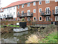
6
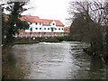
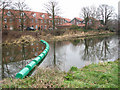
View across the mill pond
The mill is mentioned in the Domesday Book but sadly, the original building was demolished. Fortunately, the two tail races as well as the mill pond have survived and the site was redeveloped in 2001, this time for housing. The design was based on the original mill building: http://www.norfolkmills.co.uk/Watermills/trowse.html.
Image: © Evelyn Simak
Taken: 21 Jan 2010
0.04 miles
8
Footpath to Millgate
The path follows the course of the River Yare. The building seen in the background was built on the site of the demolished Trowse mill. The mill is mentioned in the Domesday Book but sadly, the original building was demolished. Fortunately, the two tail races as well as the mill pond have survived and the site was redeveloped in 2001, this time for housing. The design was based on the original mill building: http://www.norfolkmills.co.uk/Watermills/trowse.html.
Image: © Evelyn Simak
Taken: 21 Jan 2010
0.05 miles
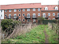
10
Flats above the tail race
The mill at Trowse is mentioned in the Domesday Book but sadly, the original building was demolished. Fortunately, the two tail races as well as the mill pond have survived and the site was redeveloped in 2001, this time for housing. The design was based on the original mill building: http://www.norfolkmills.co.uk/Watermills/trowse.html.
Image: © Evelyn Simak
Taken: 21 Jan 2010
0.06 miles