IMAGES TAKEN NEAR TO
NP9 9HZ
Introduction
This page details the photographs taken nearby to NP9 9HZ by members of the Geograph project.
The Geograph project started in 2005 with the aim of publishing, organising and preserving representative images for every square kilometre of Great Britain, Ireland and the Isle of Man.

There are currently over 7.5m images from over14,400 individuals and you can help contribute to the project by visiting https://www.geograph.org.uk
Image Map
Images are licensed for reuse under creativecommons.org/licenses/by-sa/2.0
Notes
- Clicking on the map will re-center to the selected point.
- The higher the marker number, the further away the image location is from the centre of the postcode.
Image Listing (13 Images Found)
Images are licensed for reuse under creativecommons.org/licenses/by-sa/2.0
Image
Details
Distance
1
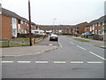
Moore Crescent, Ringland, Newport
The view south from the corner of Dawson Crescent.
Image: © Jaggery
Taken: 26 Nov 2010
0.09 miles
2
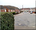
Dawson Close, Ringland, Newport
The view west from the edge of an underpass. http://www.geograph.org.uk/photo/1798257 In the distance is Hendre Farm Drive.
Image: © Jaggery
Taken: 26 Nov 2010
0.12 miles
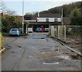
3
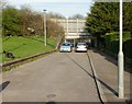
Dawson Close underpass viewed from the west
Looking along Dawson Close, Ringland towards the underpass beneath Ringland Way.
A pedestrian gate is open on the right side of the underpass entrance.
The view from the other side of the underpass. http://www.geograph.org.uk/photo/1798255
Image: © Jaggery
Taken: 9 Apr 2010
0.18 miles
4
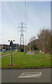
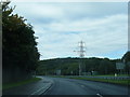
Pylon, Ringland Way, Newport
Pylon located on the east side of Ringland Way, close to the turning for Cot Hill.
Image: © Jaggery
Taken: 9 Apr 2010
0.22 miles
5
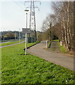
Eastern access path to Dawson Close underpass, Newport
The sign on the left of the path warns that the underpass (beneath Ringland Way) is closed every night from 7pm to 7.30am.
Image: © Jaggery
Taken: 9 Apr 2010
0.22 miles
6
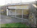
Eastern entrance to Dawson Close underpass
From a distance, the underpass under Ringland Way appeared to be closed, but a pedestrian gate is open. The local graffitists have been busy...
The view from the other side of the underpass. http://www.geograph.org.uk/photo/1798257
Image: © Jaggery
Taken: 9 Apr 2010
0.22 miles
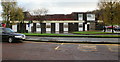
7
Ringland Labour Club, Newport
Set back from Ringland Circle, adjacent to Ringland Health Centre. http://www.geograph.org.uk/photo/1583483
Image: © Jaggery
Taken: 15 Nov 2009
0.22 miles
8
The Friendship Inn, Ringland
Pub located at the Ringland Centre.
Image: © Jaggery
Taken: 15 Nov 2009
0.22 miles
10
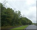
A48, Southern Distributor Road, south of Coldra
Image: © David Smith
Taken: 28 Sep 2021
0.24 miles