IMAGES TAKEN NEAR TO
Llangattock, CRICKHOWELL, NP8 1HG
Introduction
This page details the photographs taken nearby to NP8 1HG by members of the Geograph project.
The Geograph project started in 2005 with the aim of publishing, organising and preserving representative images for every square kilometre of Great Britain, Ireland and the Isle of Man.

There are currently over 7.5m images from over14,400 individuals and you can help contribute to the project by visiting https://www.geograph.org.uk
Image Map
Images are licensed for reuse under creativecommons.org/licenses/by-sa/2.0
Notes
- Clicking on the map will re-center to the selected point.
- The higher the marker number, the further away the image location is from the centre of the postcode.
Image Listing (277 Images Found)
Images are licensed for reuse under creativecommons.org/licenses/by-sa/2.0
Image
Details
Distance
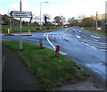
1
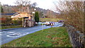
A4077 at Llangattock
Traffic is queuing at the lights controlling Crickhowell Bridge.
The building surrounded by scaffolding is The Vine Tree PH.
See Image
Image: © Jonathan Billinger
Taken: 29 Jan 2015
0.01 miles
2
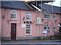
The Vine Tree PH
Positioned on the A4077 at Llangattock near Crickhowell Bridge.
Image: © Jonathan Billinger
Taken: 29 Jan 2015
0.01 miles
3

Giles Davies Ltd building site notice, Legar near Crickhowell
The notice is on the white door facing the A4077, at the edge of the derelict former Vine Tree pub,
viewed in late November 2015. Text on the notice includes
"All visitors to report to site foreman" "No Smoking" and "Keep Out".
Image: © Jaggery
Taken: 22 Nov 2015
0.01 miles
5
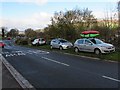
Cars parked on a grass verge in Legar
Alongside the A4077 in Legar, a hamlet near Crickhowell.
Image: © Jaggery
Taken: 22 Nov 2015
0.01 miles
6

Empty car park opposite the Vine Tree, Legar
No cars here today, a Sunday in late November 2015.
The Vine Tree http://www.geograph.org.uk/photo/4757547 on the opposite side of the A4077 is no longer in business.
The arches of Crickhowell Bridge over the River Usk are in the background.
Image: © Jaggery
Taken: 22 Nov 2015
0.01 miles
7
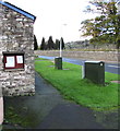
Llangattock Community Council noticeboard
On the corner of the A4077 and Hillside Road, 100 metres from the Llangattock village boundary sign. http://www.geograph.org.uk/photo/4747611
There are two notices on display on November 22nd 2015. One shows the agenda for the next council meeting. The other one announces that a poll for the election of one Community Councillor will be held on Thursday November 26th 2015 between the hours of 07:00 and 22:00
Image: © Jaggery
Taken: 22 Nov 2015
0.01 miles
8
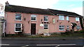
Vine Tree, Legar near Crickhowell
This late November 2015 view across the A4077 near the corner of Hillside Road shows derelict premises.
Various websites confirm that the Vine Tree is permanently closed.
Image: © Jaggery
Taken: 22 Nov 2015
0.01 miles
9
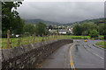
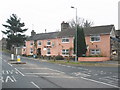
Hillside Road, Llangattock
Looking down Hillside Road towards its junction with the A4077. Crickhowell and the cloud-shrouded Black Mountains lie beyond.
Image: © Stephen McKay
Taken: 21 Jul 2009
0.01 miles
10
Turn left for Llangattock
The sign faces the A4077 at the northwest edge of the hamlet of Legar.
The right turn 100 metres ahead leads to Crickhowell via Crickhowell Bridge over the River Usk.
Image: © Jaggery
Taken: 22 Nov 2015
0.01 miles