IMAGES TAKEN NEAR TO
Brookfields, CRICKHOWELL, NP8 1DJ
Introduction
This page details the photographs taken nearby to Brookfields, NP8 1DJ by members of the Geograph project.
The Geograph project started in 2005 with the aim of publishing, organising and preserving representative images for every square kilometre of Great Britain, Ireland and the Isle of Man.

There are currently over 7.5m images from over14,400 individuals and you can help contribute to the project by visiting https://www.geograph.org.uk
Image Map (Loading...)


Getting Data...Please wait
Leaflet Map data © OpenStreetMap
Images are licensed for reuse under creativecommons.org/licenses/by-sa/2.0
Notes
- Clicking on the map will re-center to the selected point.
- The higher the marker number, the further away the image location is from the centre of the postcode.
Image Listing (45 Images Found)
Images are licensed for reuse under creativecommons.org/licenses/by-sa/2.0
Image
Details
Distance
1
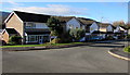
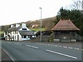
Brookfields, Crickhowell
Houses near Cwmbeth Brook, viewed from Everest Drive. The sign on the left shows BROOKFIELDS 1-45.
Image: © Jaggery
Taken: 22 Nov 2015
0.03 miles
2
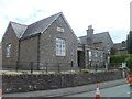
Arts Alive, The Old School, Crickhowell
The Old School, Brecon Road (A40) was formerly The British School, dating from the
1870s. The school was built following the 1870 Education Act which made it compulsory for every child to attend school. The building is now occupied by Arts Alive, an arts organisation which encourages young people and adults to explore and develop their creative talents through a wide variety of arts activities.
Image: © Jaggery
Taken: 19 Jun 2011
0.04 miles
3
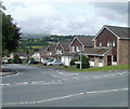
Everest Drive, Crickhowell
Houses on the west side of the road, viewed across Brecon Road (A40).
Image: © Jaggery
Taken: 19 Jun 2011
0.04 miles
4
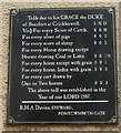
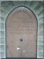
16th century tolls, White Hart, Crickhowell
This is one of two boards on the external walls of the White Hart. http://www.geograph.org.uk/photo/2468776
It records the tolls payable for using the road in the 16th century. At that time, the White Hart was a coaching inn and toll house.
It may be a fairly recent recreation of an older sign, based on the modern-day spellings (though the use of capital letters appears idiosyncratic, with horse or Horse and Score or score used). Or it may be from perhaps the 18th century, if the tolls were unchanged since 1587.
Image: © Jaggery
Taken: 19 Jun 2011
0.05 miles
5
The White Hart
Image: © Jennifer Luther Thomas
Taken: 8 Dec 2006
0.05 miles
6
Cumbeth Brook and drinking fountain.
The brook can just be seen through the gap in the stone wall.
Image: © Jennifer Luther Thomas
Taken: 8 Dec 2006
0.05 miles
8
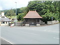
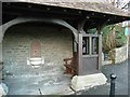
Former drinking fountain, Crickhowell
Near the western edge of Crickhowell, a roofed structure encloses a drinking fountain http://www.geograph.org.uk/photo/291938 installed in the 1890s. The fountain is no longer in use.
The gap in the wall on the right side of the structure leads down to Cwmbeth Brook.
Image: © Jaggery
Taken: 19 Jun 2011
0.05 miles
9
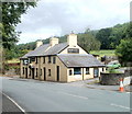
The White Hart, Crickhowell
Located alongside the A40, at the western edge of Crickhowell. The A40 here follows a centuries-old route through mid Wales. A sign on the pub states that the White Hart began as a 15th century coaching inn and toll house.
Image: © Jaggery
Taken: 19 Jun 2011
0.05 miles
10
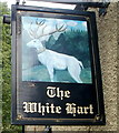
The White Hart pub sign, Crickhowell
The white hart (male deer) was the personal emblem of King Richard II of England (reigned 1377-1399). To emphasise the royal connection, this white hart has a crown around its neck. The pub http://www.geograph.org.uk/photo/2468776 is on the A40 at the western edge of Crickhowell.
White Hart is reckoned to be the fifth most common pub name in the UK. First to fourth are Crown, Red Lion, Royal Oak and Swan.
Image: © Jaggery
Taken: 19 Jun 2011
0.05 miles