IMAGES TAKEN NEAR TO
Castle Road, CRICKHOWELL, NP8 1AP
Introduction
This page details the photographs taken nearby to Castle Road, NP8 1AP by members of the Geograph project.
The Geograph project started in 2005 with the aim of publishing, organising and preserving representative images for every square kilometre of Great Britain, Ireland and the Isle of Man.

There are currently over 7.5m images from over14,400 individuals and you can help contribute to the project by visiting https://www.geograph.org.uk
Image Map
Images are licensed for reuse under creativecommons.org/licenses/by-sa/2.0
Notes
- Clicking on the map will re-center to the selected point.
- The higher the marker number, the further away the image location is from the centre of the postcode.
Image Listing (457 Images Found)
Images are licensed for reuse under creativecommons.org/licenses/by-sa/2.0
Image
Details
Distance
1
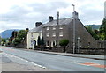
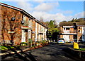
Greenhill Villas, Crickhowell
Two houses near the SE end of Beaufort Street, the local name for the A40.
Image: © Jaggery
Taken: 19 Jun 2011
0.01 miles
2
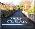
KEEP CLEAR on Castle Road, Crickhowell
Painted on the road surface opposite a house driveway.
Image: © Jaggery
Taken: 19 Dec 2014
0.02 miles
3
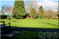
East side of Castle Park, Crickhowell
Between Castle Road on this side and the A40 Beaufort Street.
Image: © Jaggery
Taken: 19 Dec 2014
0.05 miles
4
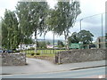
Entrance to sports grounds, Crickhowell
Viewed across Beaufort Street. The entrance road leads to playing areas for cricket, tennis and bowls. The southern edge of the sports area is bounded by Castle Road.
Image: © Jaggery
Taken: 19 Jun 2011
0.05 miles
5
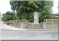
Crickhowell War Memorial
Seven steps lead up to the War Memorial on the side of the A40 (Beaufort Street).
The 3 metre (10 feet) high granite stone is located near the site of the demolished Crickhowell War Memorial Hospital.
Image: © Jaggery
Taken: 19 Jun 2011
0.05 miles
6
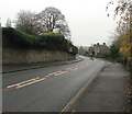
Towards a bend in the A40, Crickhowell
Ahead for Abergavenny. Behind the camera for Crickhowell town centre.
Image: © Jaggery
Taken: 29 Nov 2020
0.06 miles
7
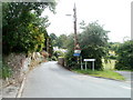
Llangenny Lane, Crickhowell
Viewed from the corner of the A40. Signs warn of a 25% (1 in 4) gradient ahead, and state that the route is unsuitable for HGVs (Heavy Goods Vehicles).
Image: © Jaggery
Taken: 19 Jun 2011
0.06 miles
8
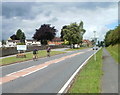
Racing into Crickhowell
Two racing cyclists on the A40 enter the SE edge of Crickhowell at speed.
The boundary sign shows that Crickhowell is twinned with Scaër, a commune in the Finistère department in Brittany, NW France.
Image: © Jaggery
Taken: 19 Jun 2011
0.06 miles
9
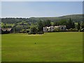
Crickhowell: the cricket ground (under preparation...)
Image: © Keith Salvesen
Taken: 17 Jun 2010
0.07 miles
10
Bench and grit box, Castle Road, Crickhowell
Near the A40 junction. The sign on the wall shows CASTLE ROAD 11-20.
Image: © Jaggery
Taken: 19 Dec 2014
0.07 miles