IMAGES TAKEN NEAR TO
Nantyderry, ABERGAVENNY, NP7 9DR
Introduction
This page details the photographs taken nearby to NP7 9DR by members of the Geograph project.
The Geograph project started in 2005 with the aim of publishing, organising and preserving representative images for every square kilometre of Great Britain, Ireland and the Isle of Man.

There are currently over 7.5m images from over14,400 individuals and you can help contribute to the project by visiting https://www.geograph.org.uk
Image Map
Images are licensed for reuse under creativecommons.org/licenses/by-sa/2.0
Notes
- Clicking on the map will re-center to the selected point.
- The higher the marker number, the further away the image location is from the centre of the postcode.
Image Listing (56 Images Found)
Images are licensed for reuse under creativecommons.org/licenses/by-sa/2.0
Image
Details
Distance
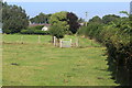
1
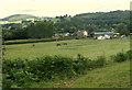
Glen View Farm, Nantyderry
Viewed from Star Road.
Image: © Jaggery
Taken: 30 Jun 2011
0.01 miles
2
Road to Nantyderry from Chain Bridge
Viewed across the B4598 on the NW side of this bridge. http://www.geograph.org.uk/photo/2821237 The road ahead is Chain Bridge Road.
The sign on the left shows a weight restriction of 7.5 tonnes ahead, except for loading.
Image: © Jaggery
Taken: 30 Jun 2011
0.02 miles
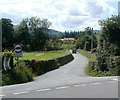
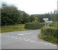
3
Crossroads near Chain Bridge, Monmouthshire
Looking SE along Chain Bridge Road. This way also for Usk (4 miles).
Turn left for Clytha and Raglan, or right for Penperlleni and Pontypool.
The sign arm pointing towards the camera shows Nantyderry and Abergavenny.
Image: © Jaggery
Taken: 30 Jun 2011
0.03 miles
4
Chain Bridge Road, Nantyderry, Monmouthshire
Ahead for this https://www.geograph.org.uk/photo/2821237 bridge over the River Usk and the town of Usk.
Image: © Jaggery
Taken: 21 Aug 2022
0.05 miles
5
Gates at start of track from field
The grass track leads to Chain Bridge Road.
Image: © M J Roscoe
Taken: 15 Sep 2021
0.08 miles
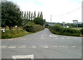
6
Crossroads near the Chain Bridge
The rural location is in central Monmouthshire.
Distances shown (miles) include 7½ to Raglan, 5 to Pontypool and 6½ to Abergavenny.
Image: © Jaggery
Taken: 30 Jun 2011
0.12 miles
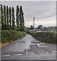
7
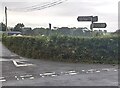
Directions and distances signs at crossroads in rural Monmouthshire
The signs are very grubby in August 2022.
The sign pointing left shows Chain Bridge ¼ (mile), Usk 4
The sign pointing right shows Penperlleni 1½, Pontypool 5
The sign pointing behind the camera shows Nantyderry ½, Abergavenny 6½
The fourth sign shows Clytha 4, Raglan 7
Image: © Jaggery
Taken: 21 Aug 2022
0.12 miles
8
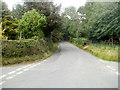
Pengam Lane near Chain Bridge, Monmouthshire
Viewed from crossroads. http://www.geograph.org.uk/photo/3323368 Pengam Lane leads to Clytha and Raglan.
Image: © Jaggery
Taken: 30 Jun 2011
0.12 miles
9
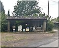
Abandoned filling station, Nantyderry, Monmouthshire
Weeds and the derelict appearance in August 2022 suggest that the filling station located near crossroads has not been used recently.
Image: © Jaggery
Taken: 21 Aug 2022
0.13 miles
10
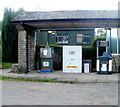
Old-style fuel pumps near Chain Bridge
Notices state that the owner has had to close down the pumps because of illness.
http://www.geograph.org.uk/photo/3288430 to a wider view.
Image: © Jaggery
Taken: 30 Jun 2011
0.13 miles