IMAGES TAKEN NEAR TO
Hardwick, ABERGAVENNY, NP7 9BS
Introduction
This page details the photographs taken nearby to NP7 9BS by members of the Geograph project.
The Geograph project started in 2005 with the aim of publishing, organising and preserving representative images for every square kilometre of Great Britain, Ireland and the Isle of Man.

There are currently over 7.5m images from over14,400 individuals and you can help contribute to the project by visiting https://www.geograph.org.uk
Image Map (Loading...)


Getting Data...Please wait
Leaflet Map data © OpenStreetMap
Images are licensed for reuse under creativecommons.org/licenses/by-sa/2.0
Notes
- Clicking on the map will re-center to the selected point.
- The higher the marker number, the further away the image location is from the centre of the postcode.
Image Listing (18 Images Found)
Images are licensed for reuse under creativecommons.org/licenses/by-sa/2.0
Image
Details
Distance
1
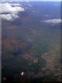
Abergavenny from the air
The A465 Heads of the Valleys road and the River Usk can be seen to the left of the town. Llanfoist is to the left of the road. Viewed from a Bristol bound flight from Glasgow.
Image: © Thomas Nugent
Taken: 2 Apr 2012
0.05 miles
2
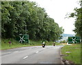
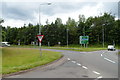
A40 approaches a major junction in the south of Abergavenny
This carriageway of the A40 is here about 130 metres from the opposite A40 carriageway, on the approach to a major junction at a large roundabout ahead.
Roads meeting at the junction are the A4042 from Newport, the A465 Heads of the Valleys Road from Merthyr Tydfil, the continuation of the A40 to central Abergavenny, Brecon and points west, and the A465 to Hereford.
Image: © Jaggery
Taken: 15 Jul 2012
0.11 miles
3

Crossed lines
Power cables over the railway line which is crossing the roundabout which forms the junction of the A40, A465, A4042 and the B4598.
Image: © Jennifer Luther Thomas
Taken: 23 Nov 2006
0.11 miles
4
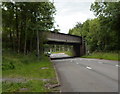
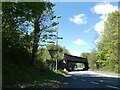
Nantoer railway bridge, Abergavenny
This is one of two bridges carrying the Welsh Marches Line over the A40 about a kilometre south of Abergavenny railway station. This one carries the railway over the Abergavenny-bound carriageway of the A40. The other bridge is about 130 metres to the north, over the carriageway for vehicles leaving Abergavenny. The identification on the roadside wall of the bridge is Nantoer 23m 34c HNL.
Kevin Flynn says that this indicates 23 miles and 34 chains from Rotherwas Junction on the Hereford and Newport Line. Rotherwas, a mile south of Hereford station, is no longer a junction. It was where the line to Ross-on-Wye (which closed in 1964) diverged from the main line.
Image: © Jaggery
Taken: 15 Jul 2012
0.11 miles
6
Railway bridge over A40 roundabout south of Abergavenny
Image: © David Smith
Taken: 28 Apr 2023
0.14 miles
7
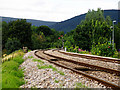
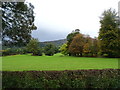
The Marches Line
View of the marches railway line just south of Abergavenny. In the distance can be seen one of the far more pleasing semaphore signals
Image: © Stuart Wilding
Taken: 19 Jul 2008
0.14 miles
8
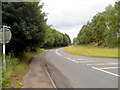
B4598 heads south away from the A40, Abergavenny
Formerly the road ahead, now the B4598, was the A40. It was reclassified after a new dual carriageway road nearby became the A40. For several miles ahead, in the direction of Raglan, the B4598 and the A40 follow more or less parallel routes, about 100 metres apart.
Image: © Jaggery
Taken: 15 Jul 2012
0.17 miles
9
Northern end of the B4598, Abergavenny
The Give Way sign is at the northern of the B4598, at the junction with the A40.
For several miles to the south east and then east, the road that is now the B4598 was formerly the A40, before the opening of the dual carriageway that is now the A40.
Image: © Jaggery
Taken: 15 Jul 2012
0.17 miles
10
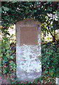
Old Milestone by the A4042, south of Abergavenny
Milestone by the A4042, in parish of Abergavenny (Monmouthshire District), just south of roundabout at junction with the A465, in front of hedge, East side of road.
Inscription reads:-
ABERGAVENNY
1
PONTYPOOL
9
Surveyed
Milestone Society National ID: MON_AGPP01
Image: © Milestone Society
Taken: Unknown
0.18 miles