IMAGES TAKEN NEAR TO
Llanvair Kilgeddin, ABERGAVENNY, NP7 9BB
Introduction
This page details the photographs taken nearby to NP7 9BB by members of the Geograph project.
The Geograph project started in 2005 with the aim of publishing, organising and preserving representative images for every square kilometre of Great Britain, Ireland and the Isle of Man.

There are currently over 7.5m images from over14,400 individuals and you can help contribute to the project by visiting https://www.geograph.org.uk
Image Map
Images are licensed for reuse under creativecommons.org/licenses/by-sa/2.0
Notes
- Clicking on the map will re-center to the selected point.
- The higher the marker number, the further away the image location is from the centre of the postcode.
Image Listing (13 Images Found)
Images are licensed for reuse under creativecommons.org/licenses/by-sa/2.0
Image
Details
Distance
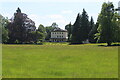
1

Pant-y-Goitre House near Llanvihangel Gobion
A beautiful country house set in mature parkland beside the River Usk.
Image: © Jeremy Bolwell
Taken: 25 Feb 2012
0.10 miles
2
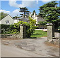
Grade II Listed Pant-y-Goitre House, Llanfair Kilgeddin, Monmouthshire
Built in c1726 with later major changes. Grade II listed in 1956.
Image: © Jaggery
Taken: 14 May 2017
0.10 miles
3
Pant-y-Goitre house
Currently for sale at £1.2 million ... It's Georgian, with an earlier Queen Anne building attached to it, and it has an orangery which I think is the long low building extending off the right of the main house. Whatever, it's a lovely house but I don't think I could quite stretch to the purchase price! Taken from the Usk Valley Walk on the opposite bank of the river.
Image: © John Winder
Taken: 21 Apr 2014
0.10 miles
4
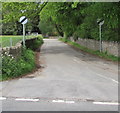
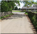
Minor road west from Llanfair Kilgeddin, Monmouthshire
Viewed across the B4598. A nearby sign http://www.geograph.org.uk/photo/5390440 pointing this way shows Llanvair Cross 1 (mile), Goytre 2½.
The 50mph speed limit increases to the National Speed Limit ahead.
Image: © Jaggery
Taken: 14 May 2017
0.11 miles
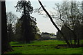
5
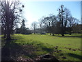
Pant y Goitre House & Park
Georgian (late 1700s) northern block of country house (now sub-divided) on southern edge of open pasture parkland with specimen trees.
Image: © M J Roscoe
Taken: 8 Jun 2021
0.12 miles
6
End of the National Speed Limit, Llanfair Kilgeddin, Monmouthshire
The National Speed Limit on the minor road from Llanvair Cross
and Goytre drops to 50mph on the approach to the B4598 junction.
Image: © Jaggery
Taken: 14 May 2017
0.14 miles
7
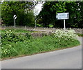
Direction and distances sign, Llanfair Kilgeddin, Monmouthshire
Facing northbound traffic on the B4598 on the corner of this http://www.geograph.org.uk/photo/5390433 minor road junction.
Image: © Jaggery
Taken: 14 May 2017
0.15 miles
8
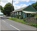
Llanfair Kilgeddin Village Hall
Corrugated metal building on the west side of the B4598 in rural Monmouthshire between Usk and Abergavenny.
http://www.geograph.org.uk/photo/5390430 to another view of the hall.
Image: © Jaggery
Taken: 14 May 2017
0.15 miles
9
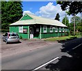
Llanfair Kilgeddin Village Hall
Corrugated metal building on the west side of the B4598 in rural Monmouthshire between Usk and Abergavenny.
http://www.geograph.org.uk/photo/5390425 to another view of the hall.
Image: © Jaggery
Taken: 14 May 2017
0.15 miles
10
Pant-y-Goitre House at Llanvihangel Gobion
A beautiful grade II listed Georgian country house situated near the River Usk. Built in 1776 the house and grounds are in a magnificent setting.
Image: © Jeremy Bolwell
Taken: 25 Feb 2012
0.16 miles