IMAGES TAKEN NEAR TO
Llanvapley, ABERGAVENNY, NP7 8SP
Introduction
This page details the photographs taken nearby to NP7 8SP by members of the Geograph project.
The Geograph project started in 2005 with the aim of publishing, organising and preserving representative images for every square kilometre of Great Britain, Ireland and the Isle of Man.

There are currently over 7.5m images from over14,400 individuals and you can help contribute to the project by visiting https://www.geograph.org.uk
Image Map
Images are licensed for reuse under creativecommons.org/licenses/by-sa/2.0
Notes
- Clicking on the map will re-center to the selected point.
- The higher the marker number, the further away the image location is from the centre of the postcode.
Image Listing (5 Images Found)
Images are licensed for reuse under creativecommons.org/licenses/by-sa/2.0
Image
Details
Distance
1
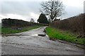
Crossways
Crossways Farm, now a private residence and named Crossways. In older times known possibly more appropriately as THE CROSS. This is the junction of the FIRS Road (running N/S) and an ancient unpaved road (running W/E). This old road was reputed, in ancient times to be the "main" road from Abergavenny to Whitecastle, a medieval Castle 5 miles to the East. The old road is a public right of way, it is still usable/walkable, but some of it has been levelled and cleared by the nearby land owners.
Image: © RAY JONES
Taken: 12 Jan 2007
0.04 miles
2
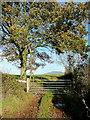
Field entrance opposite Crossways
The eye is drawn to Edmund's Tump beyond.
Image: © Jonathan Billinger
Taken: 17 Nov 2011
0.07 miles
3
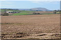
View to Blorenge
View across farmland to Blorenge, Parc-gwyn is the farm to the left in the middle distance.
Image: © Philip Halling
Taken: 15 Mar 2014
0.08 miles
4
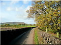
Lane and The Skirrid
The distinctive upturned-boat shape of the hill viewed along a lane near Great Blaen-coed.
Image: © Jonathan Billinger
Taken: 17 Nov 2011
0.21 miles
5
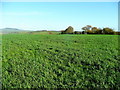
Grassland of the Trothy valley
In the distance is Edmund's Tump.
Image: © Jonathan Billinger
Taken: 17 Nov 2011
0.21 miles