IMAGES TAKEN NEAR TO
Wern Gifford, ABERGAVENNY, NP7 8RT
Introduction
This page details the photographs taken nearby to Wern Gifford, NP7 8RT by members of the Geograph project.
The Geograph project started in 2005 with the aim of publishing, organising and preserving representative images for every square kilometre of Great Britain, Ireland and the Isle of Man.

There are currently over 7.5m images from over14,400 individuals and you can help contribute to the project by visiting https://www.geograph.org.uk
Image Map
Images are licensed for reuse under creativecommons.org/licenses/by-sa/2.0
Notes
- Clicking on the map will re-center to the selected point.
- The higher the marker number, the further away the image location is from the centre of the postcode.
Image Listing (18 Images Found)
Images are licensed for reuse under creativecommons.org/licenses/by-sa/2.0
Image
Details
Distance
1
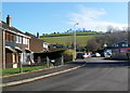
Wern Gifford houses, Pandy
Wern Gifford is an area of housing built in the 1970s on the east side of the A465.
Image: © Jaggery
Taken: 19 Feb 2012
0.03 miles
2
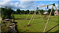
Play and sports ground, Werngifford
Werngifford is a community off the A465 midway between Llanvihangel Crucorney and Pandy.
Image: © Jonathan Billinger
Taken: 5 Jul 2016
0.08 miles
3
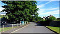
Werngifford
Werngifford is a community off the A465 midway between Llanvihangel Crucorney and Pandy. To the left is the community hall.
Image: © Jonathan Billinger
Taken: 5 Jul 2016
0.10 miles
4
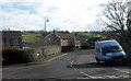
Wern Gifford, Pandy
Viewed across the A465. Wern Gifford is an area of housing built in the 1970s.
Image: © Jaggery
Taken: 19 Feb 2012
0.11 miles
5
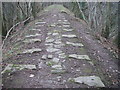
Grosmont Tramroad
Behind Werngifford are the remains of the tramroad built in the early C19th. It formerly connected with the Llanfihangel Tramroad to form a through route between Abergavenny and Hereford until replaced by the modern railway in 1854. The original proposals of 1792 were for a canal on this route but that was never built.
Image: © Alan Bowring
Taken: 18 Dec 2007
0.11 miles
6
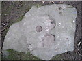
Detail of tramroad block
The block was secured in the ground by means of an iron spike and the stone has been shaped to receive a flange onto which were fastened the iron plates which served as rails. Many similar stones can be seen on the section of tramway raised on an embankment behind Werngifford - see Image
Image: © Alan Bowring
Taken: 18 Dec 2007
0.12 miles
7
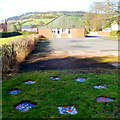
Pandy Village Hall
Looking past a circle of 8 rectangular mosaics towards the hall in Wern Gifford Estate.
Image: © Jaggery
Taken: 19 Feb 2012
0.13 miles
8
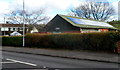
Pandy Village Hall
Viewed across the A465. The hall is in Wern Gifford, Pandy.
Image: © Jaggery
Taken: 19 Feb 2012
0.14 miles
9
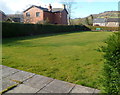
Pandy Bowls Club bowling green
Alongside the village hall http://www.geograph.org.uk/photo/3790170 in Wern Gifford.
Image: © Jaggery
Taken: 19 Feb 2012
0.15 miles
10

Unnamed stream, Pandy
Viewed from the edge of the A465 in the south of Pandy.
The stream is a tributary of the Afon Honddu, into which it flows about 450 metres behind the camera.
Image: © Jaggery
Taken: 19 Feb 2012
0.15 miles