IMAGES TAKEN NEAR TO
Grosmont, ABERGAVENNY, NP7 8ET
Introduction
This page details the photographs taken nearby to NP7 8ET by members of the Geograph project.
The Geograph project started in 2005 with the aim of publishing, organising and preserving representative images for every square kilometre of Great Britain, Ireland and the Isle of Man.

There are currently over 7.5m images from over14,400 individuals and you can help contribute to the project by visiting https://www.geograph.org.uk
Image Map
Images are licensed for reuse under creativecommons.org/licenses/by-sa/2.0
Notes
- Clicking on the map will re-center to the selected point.
- The higher the marker number, the further away the image location is from the centre of the postcode.
Image Listing (135 Images Found)
Images are licensed for reuse under creativecommons.org/licenses/by-sa/2.0
Image
Details
Distance
1
Grosmont City Limits
The antique AA sign has probably been relocated but is no less accurate being positioned on the western edge of the village.
Image: © Jonathan Billinger
Taken: 17 Nov 2011
0.02 miles
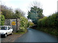
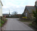
2
Road from Grosmont to Abergavenny
A sign behind the camera, on the corner of the B4347 junction, shows that it is 11 miles to Abergavenny.
Image: © Jaggery
Taken: 19 Feb 2012
0.04 miles
3
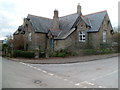
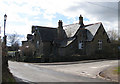
Grade II listed The Old School, Grosmont
The former Grosmont Junior and Infants County School is on the corner of the B4347 and the road to Abergavenny. Grade II listed in September 1990.
The nearest primary school is about 3 miles (c5km) away, in Cross Ash.
Image: © Jaggery
Taken: 19 Feb 2012
0.06 miles
4
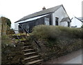
Former Grosmont Mission Hall
Steps from the road to Abergavenny lead up to the closed Grosmont Mission Hall.
Image: © Jaggery
Taken: 19 Feb 2012
0.06 miles
5
Right turn to Abergavenny
The building, now a dwelling appears to be a former school with a date stone of 1877. (Possibly the Board School).
Image: © Pauline E
Taken: 4 Mar 2009
0.07 miles
6
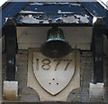
Date stone and bell
On the building which I think is the former Board School. Image
Image: © Pauline E
Taken: 4 Mar 2009
0.07 miles
7
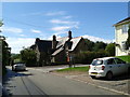
Houses in Grosmont, and the road to Abergavenny
Image: © Rob Purvis
Taken: 26 Aug 2015
0.08 miles
8
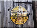
Old circular AA Sign on a minor road in Grosmont
Old AA Sign set on a wooden garage door north of a minor road 330 yards west of its junction with the B4347 in Grosmont, 11½ miles northeast of Abergavenny. Grosmont community.
This is the circular, village name on black band, no Motor Union symbol or name type, dating from 1923, and showing distances Abergavenny 10¾ Monmouth 11¾ London 135¼.
There were five series of AA signs, mostly dating from 1923 and made by Francis & Co / Franco in Deptford, London. The village name and distance to London were displayed.
See also https://www.flickr.com/photos/julianinlondon/9060201801 , https://www.flickr.com/photos/bazzadarambler/3663707774 and https://www.geograph.org.uk/photo/2752043.
Milestone Society National ID: MON-GROS
Image: © Milestone Society
Taken: Unknown
0.09 miles
9
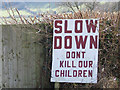
Hand painted sign
Blunt but effective message by the B4347 entering Grosmont from the north.
Image: © Pauline E
Taken: 4 Mar 2009
0.10 miles
10
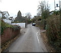
Road from Abergavenny reaches Grosmont
Looking along the eastern end of the road from Abergavenny. Ahead is the B4347 junction. The Old School is on the right. Turn left for Kentchurch (1½ miles) or Hereford (11 miles).
Turn right for Grosmont castle, church and the centre of the village. Skenfrith is 5 miles away and Monmouth 11 miles.
Image: © Jaggery
Taken: 19 Feb 2012
0.10 miles