IMAGES TAKEN NEAR TO
Forest Coal Pit, ABERGAVENNY, NP7 7LU
Introduction
This page details the photographs taken nearby to NP7 7LU by members of the Geograph project.
The Geograph project started in 2005 with the aim of publishing, organising and preserving representative images for every square kilometre of Great Britain, Ireland and the Isle of Man.

There are currently over 7.5m images from over14,400 individuals and you can help contribute to the project by visiting https://www.geograph.org.uk
Image Map
Images are licensed for reuse under creativecommons.org/licenses/by-sa/2.0
Notes
- Clicking on the map will re-center to the selected point.
- The higher the marker number, the further away the image location is from the centre of the postcode.
Image Listing (15 Images Found)
Images are licensed for reuse under creativecommons.org/licenses/by-sa/2.0
Image
Details
Distance
1
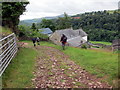
Upper House
Cerddwyr yn mynd heibio i ffarm o'r enw Upper House.
Walkers passing a farm known as Upper House.
Image: © Alan Richards
Taken: 10 Jul 2016
0.01 miles
2
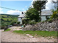
Upper House Farm in the Grwyne Valley
A lovely whitewashed farmhouse with old cobbled farmyard and old walling. Lovely spot in summer. But I expect they manage in winter. The farmers of the Black Mountains are nothing if not hardy.
Image: © Jeremy Bolwell
Taken: 31 May 2011
0.01 miles
3
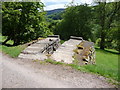
Vehicle inspection pit at Upper House Farm
Ingenious homemade car inspection facility built alongside the farm drive. No doubt modern health and safety would have something to say about it but it gets the job done.
Image: © Jeremy Bolwell
Taken: 31 May 2011
0.05 miles
4
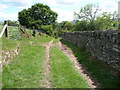
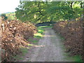
Field access track above Upper House Farm
This walled and fenced track enables sheep to be driven up onto the moor and of course brought back down too. It also carries part of the Beacons Way long-distance footpath.
Image: © Jeremy Bolwell
Taken: 31 May 2011
0.14 miles
5
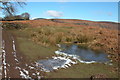
View towards Bal Mawr, Black Mountains
This view looking north is from above Coed Robin.
Image: © Philip Halling
Taken: 4 Mar 2006
0.14 miles
7
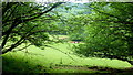
The Grwyne Fawr valley
Beef cattle in the lush green pasture of the valley floor.
Image: © Jonathan Billinger
Taken: 7 Jun 2016
0.19 miles
8
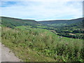
In the Llanthony Valley
The glacier took a deviation here.
Image: © Jeremy Bolwell
Taken: 8 Sep 2012
0.22 miles
9
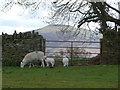
Black Mountains scene
A mother and her twin lambs with the backdrop of the Sugar Loaf.
Image: © Jeremy Bolwell
Taken: 21 Apr 2012
0.22 miles
10
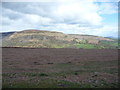
View to the Darren and the Graig above Cwmyoy
View to the landslip country of the Black Mountains.
Image: © Jeremy Bolwell
Taken: 21 Apr 2012
0.23 miles